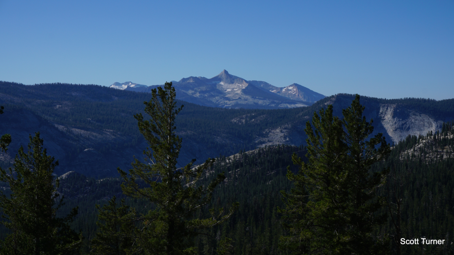
This spectacular dual-destination hike combines a mellow hike to a sparkling subalpine lake with a straightforward cross-country ascent on Mount Hoffman, which lies at the geographic center of Yosemite National Park. A 10,850′ peak in the center of the park suggests magnificent views, and those views turn out to be far more impressive than you can imagine. From the rocky summit, hikers can enjoy a panorama ranging from the western margins to the park to the northern, southern, and eastern boundaries of Yosemite, encompassing nearly all of the park’s terrain. The potential for camping overnight at May Lake’s High Sierra Camp creates the possibility for enjoying this fantastic hike in a comfortable, historic fashion.

History on the High Sierra Camps
Established in 1916 through an agreement between the Park Service and a private concessionaire, the High Sierra Camps offered mountain chalet-style accomodations to hikers wishing to explore the high country in Yosemite (and to a lesser extent, Sequoia National Park). Although the original incarnation of the camps eventually folded in bankruptcy, the concept evolved until the five primary wilderness camps (Merced Lake, May Lake, Vogelsang, Glen Aulin, and Sunrise) remained to form the famous High Sierra Camp Loop, a 51 mile loop ending and beginning at Tuolumne Meadows that visits some of Yosemite’s best high country scenery.
Today’s camps feature meals provided by camp cooks, more evolved lodging on cots inside tent cabins, and access to beautiful destinations. These conveniences eliminate the necessity of carrying a lot of backpacking gear, making the hiking and lodging far more comfortable than the usual modes of wilderness travel. If you like the backcountry and hate backpacking, this is the way to go.
Reservations & Wilderness Permits
Getting a spot in the High Sierra Camp is a challenge. The popularity of the camps means that Yosemite Hospitality, the park’s concessionaire who manages the camps, uses a lottery system not unlike Half Dome to determine who gets to stay in the camps. You can enter the lottery in fall the year before you plan to visit. You’re not guaranteed a spot, but the experience is worth the attempt. And of course, if you don’t get the reservation, you can always attempt to secure a wilderness permit to backpack at May Lake for a similar, albeit less comfortable visit.
The Yosemite Conservancy manages the wilderness permit process for Yosemite. Visit the permit reservation website, and follow the prompts on the digital form. From the drop-down menus, select Tioga Road (including May Lake) as your region, and then select May Lake as your desired trailhead. Yosemite Conservancy will then follow up with an email to let you know if you’ve been awarded a permit or not. At that point, you’ll be prompted to pay for your permit. Afterward, you can pick up your permit at either the Tuolumne Meadows Wilderness Center or the Yosemite Valley Wilderness Center.
May Lake
As mentioned above, this is a dual-destination hike, meaning that you can keep your hike specifically to May Lake, or you can include Mount Hoffman, the route for which begins from the western end of May Lake. The May Lake hike is pretty easy, and just about anybody complete it. Mount Hoffman is significantly harder, and it includes route-finding, steep grades, intense sun-exposure, and a short Class 2 scramble to the summit.

From the May Lake Trailhead, locate the trailhead between the pit toilets and a small pond. The trail skirts the west end of the pond and heads due north on a moderate incline of a well-engineered, well-traveled track. The initial hike passes through a dense forest of lodgepoles with occasional mountain hemlocks sprinkled in for seasoning. After 0.4 mile, the trail breaks through the forest cover for views east toward the Cathedral Range and south toward Clouds Rest and the Clarks Range punctuated by conifers. At 0.75 mile, the trail begins a section of switchbacks that bear the brunt of the climb while offering improved views of the aforementioned mountain ranges. At 0.9 mile, the trail crests the moraine impounding the lake on its eastern shore, at which point it turns north again to approach the May Lake High Sierra Camp.

At 1.1 miles, the trail will split upon reaching the camp’s toilet and hitching posts. If you wish to continue to the High Sierra Camp, which lies on the lake’s eastern shore, keep right at this split. The trail leads directly to and then through the camp with a few short side paths approaching the banks of the lake. Views of the lake are best on the east side just north of the camp, as you can take in the eastern wall of Mount Hoffman rising high above the lake’s sparkling waters.

If you’re only interested in hiking to May Lake and don’t have the appetite for Mount Hoffman, make a point of continuing beyond the camp. The trail leaves the hubbub of the camp behind and then passes through a pair of wildflower-flecked meadows before making a short descent to the lip of a beautiful valley. Climb up onto a low shelf to get a fantastic look east toward the Cathedral Range, punctuated by the distinct form of Cathedral Peak. Look southeast to spot the western half of Tenaya Lake lying in the heart of the valley. Continuing scanning to the south to spot Clouds Rest rising high above Tenaya Canyon. This is a great consolation prize for folks who don’t want to tackle Hoffman, as the view just from this spot is pretty phenomenal on its own.

The complete hike from the trailhead to this viewpoint is 3.5 miles with about 550 feet of elevation gain.
Mount Hoffman
To follow the route to Mount Hoffman, backtrack to the trail split 1.1 miles from the May Lake Trailhead; note that distances to Mount Hoffman are reckoned from this junction. Instead of keeping right to reach the High Sierra Camp, keep left to skirt the southern banks of May Lake. Backpackers set up shop in the woods south of the lake, and this is the place to go if you’re camping. Follow the well-trod informal path as it passes the lake’s southern shore, and begin an undulating passage at 1.4 miles that weaves through a rich mixture of red fir, mountain hemlock, and lodgepole pine. The trail turns southwest to begin climbing up to a ledge that sports some great views across May Lake to the northeast, where Mount Conness, the highest point in the Sierra north of Tioga Pass, dominates the Sierra Crest.

At 1.6 miles, the climb becomes steeper as you work through a talus field and then climb along a meadow-y creek on a southwest course. The view across May Lake vanishes as you round a bend and arrive on a second, wooded shelf at 1.8 miles. A pocket meadow lies on your right, and some nice viewpoints lie on the left, feature glances east toward Tenaya Lake and the Cathedral Range. Enjoy a brief respite from the climbing as you pass under a denser forest canopy before arriving above a larger meadow at 1.9 miles. Follow the trail as well as you can as you reach a pair of downed pines which have caused hikers to carve out a braid of new informal routes that create some confusing diversions off of the main trail. If you manage to stick to the correct trail, you will make a 90-degree turn at 1.9 miles that signals the beginning of the primary approach to Mount Hoffman.

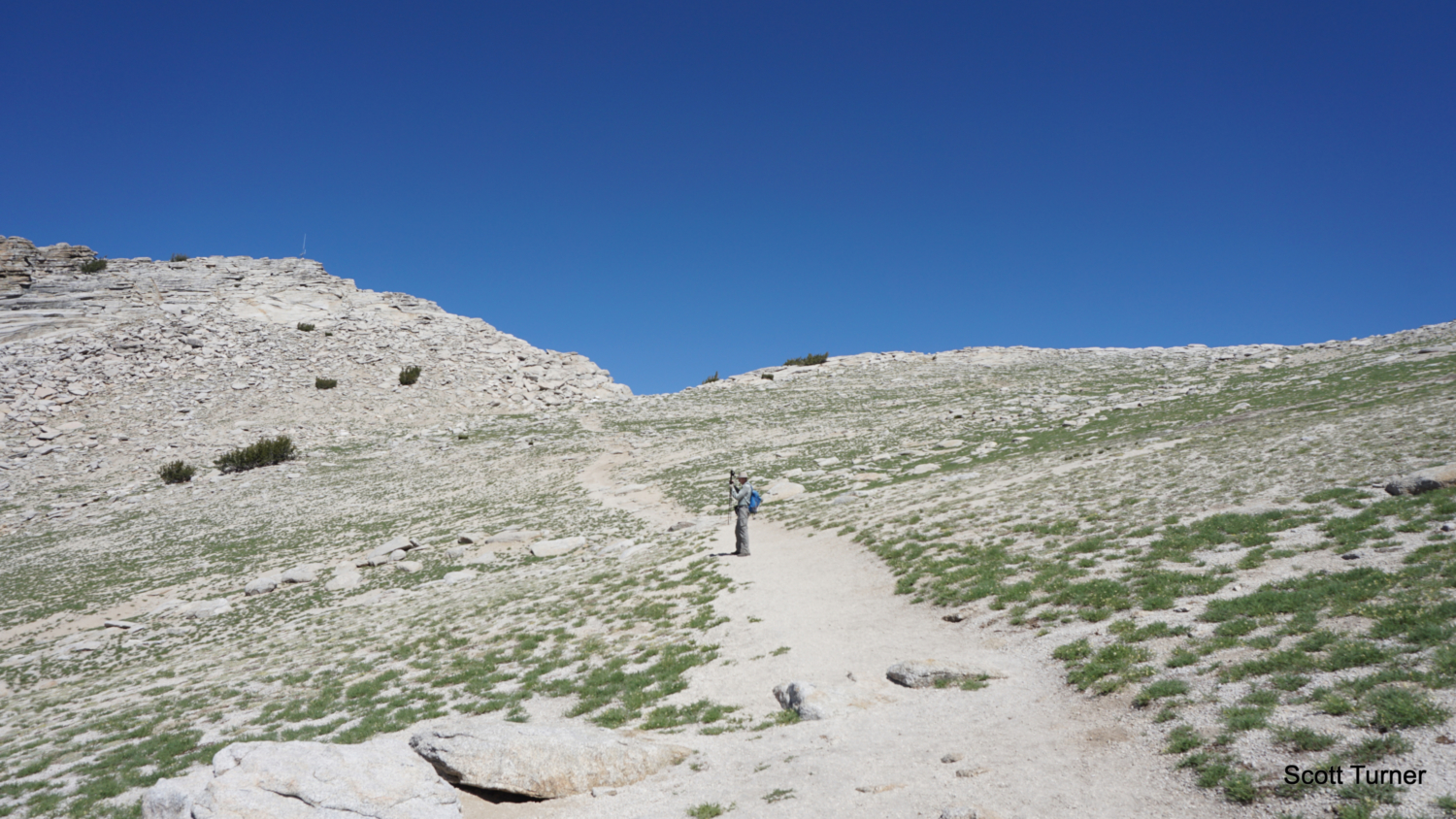
After making this turn to the northwest, the trail begins climbing away from the forest through a rocky, informal path occasionally marked by cairns. You know face a 1,200 foot climb over the next 0.9 mile as you approach the summit of Mount Hoffman. Although the terrain is easy to negotiate, some confusion will occur as hikers have created multiple parallel paths that distract from the primary path. The cairns that hikers have left can sometimes steer you away from the true path (see a brief rant about cairns at the end of this write-up), but so long as you continue uphill and northwest through sparse thickets of whitebark pine, you will eventually reach a much more clearly defined trail for the final ascent to Mount Hoffman’s summit block at 2.4 miles.

To this point, I’ve avoided mentioning the views south, which you will undoubtedly have noticed on one of your possibly numerous breaks from the stiff climb. As you look south, you’ll notice the upper reaches of Yosemite Valley, crowned by some world-famous features including Half Dome, Sentinel Dome, North Dome, and Eagle Peak. Beyond, you’ll notice the Clark Range, crowned by spire-like Mount Clark. This is just a taste of the view, as the summit reveals the northern and western halves of the park to pair with evolved and improved vistas to the south and east that you’ve already witnessed.

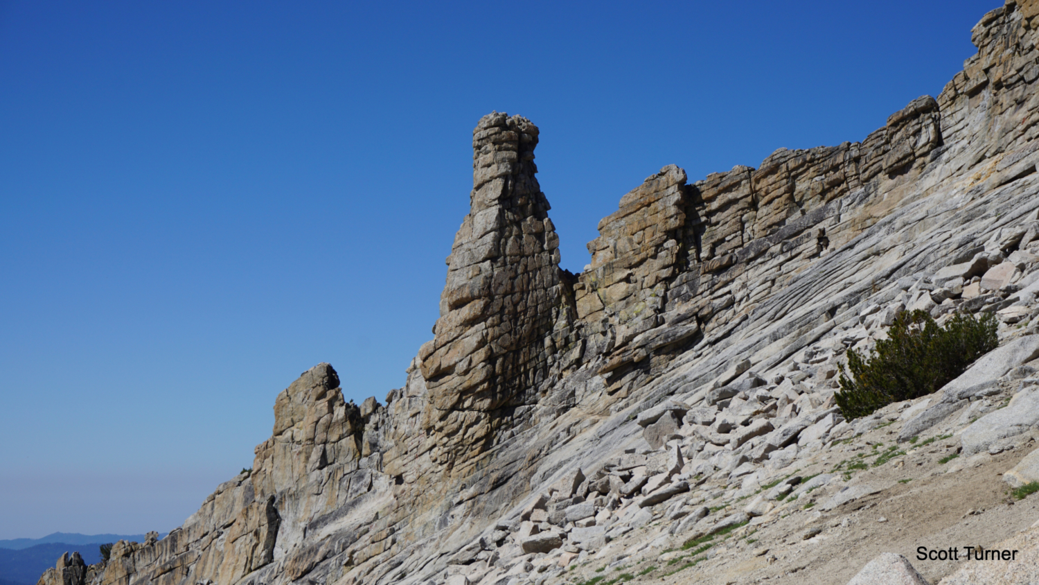
The final ascent follows a clearly defined path over sandy scree on a moderate ascent made more challenging by altitude. You pass beneath Mount Hoffman’s eastern summit blocks; they’re attainable if you’re determined, but they aren’t the true peaks. Continued following Mount Hoffman’s sandy southern face on an oblique path heading northwest until you reach the true summit block on the western end of the mountain. Keep a look out to an awesome rock chimney on the southern edge of the summit block; it’s a neat geologic feature that frames the valley views nicely.

The summit block stands above a notch that allows a first taste of the northern view. Depart from the trail at this notch, and begin a short, but steep Class 2 scramble toward the summit, which is marked by a repeater antenna. Keep to the left of the summit, as the right side of the summit is a more challenging Class 3 scramble with a few moments of exposed Class 4 scrambling. By following a series of slabs and steps to the left of the summit, you can reach the summit ridge. Turn right toward the antenna, and prepare for the full reveal of the view north.

In addition to the sweeping views south across the upper reaches of Yosemite Valley, Glacier Point, and the Clark Range, along with the eastern view toward the Cathedral Range and Sierra Crest, you now enjoy unparalleled views north across the Grand Canyon of the Tuolumne toward high points above Virginia and Matterhorn Canyons and the Rancheria Creek watershed. Crenalated mountains display Yosemite’s unparalleled high country, a spectacle that surpasses even what’s on display within Yosemite Valley. The western view is less distinctive as rolling mountains blanketed in forest yield to hazy foothills, but you can still spot some notable features out this way, including El Capitan and the Devils Dance Floor. Even a quick peak over the summit’s north face reveals a hidden wonderland of tarns and massive cliffs punctuated by nearby Tuolumne Peak. Bring a good regional map covering the park and spend a happy hour acquainting yourself with the features of this stunning panorama.

Rant
So, there are a number of reasons why cairns are dumb, bad outdoor practice, and most of those reasons relate to the sort of rock stacking people create for supposedly spiritual reasons. I won’t get into why those are flagrant violations of Leave no Trace principles, but I will talk a bit about the problems with navigational cairns. There is an informal and well-traveled route leading to Mount Hoffman, but over the years, hikers have wandered off of the trail only to create new cairns to help them find their ways back. The creation of new cairns inspires later hikers to follow those newer cairns off of the main route, which reinforces a new informal trail on sensitive mountain habitat. There are now a number of different paths that diverge and re-emerge later on, creating an unnecessary braid of trails that makes route-finding harder than it needs to be. At one point, I saw cairns within 50 feet of each other marking three separate paths.
Please refrain from building new navigational cairns. Do the hard work of locating and sticking to the original path reflected by the GPS track here. I know this is hard because the people before you have made it harder to do so. However, building more cairns only adds to the problem. And honestly, if you’re paying attention, the trail is never that hard to follow in the first place. The cairns were more of a convenience that spared a little bit of time and effort, but they were hardly even necessary in the first place. They’re necessary now because there are too many diverging paths to follow. Please don’t add more.
Tags: Clouds Rest, half dome, May Lake, May Lake High Sierra Camp, Mt. Hoffman, Polly Dome, Tenaya Lake, Tioga Road, Yosemite, Yosemite National Park, Yosemite Valley