One of the most challenging hikes in Southern California. This ascent of a long, ramp-like ridge takes you first to Villager Peak and then, after much undulating, to the remote sky island of Rabbit Peak. The views are phenomenal, and the sunsets and sunrises can be once-in-a-lifetime experiences. Not for the faint-of-heart, and certainly only for experienced hikers, this is one of the most memorable hikes you can take in Anza-Borrego Desert State Park.

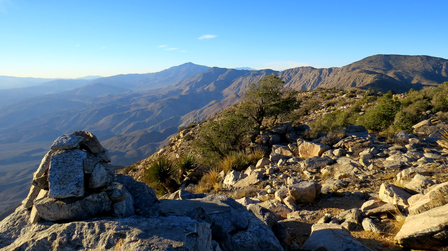
Villager Peak before sunset
If you’ve spent any amount of time in Borrego Valley, then chances are you’ve seen it staring you down, both challenging and beckoning you: a formidable wall of granite rising straight up from the desert floor and culminating in a flat, wooded summit known as Rabbit Peak. This sky island crowned with pinyon pines, meadows, and chaparral stands aloof from the rest of Southern California in one of the most isolated and difficult-to-reach parts of the region. No roads and few trails penetrate this part of the Santa Rosa Mountains, and the only way to reach the peak is to undergo the ordeal of climbing straight up a daunting ridge from the desert floor.

Pinyon snag at sunset
There are two popular routes reaching Rabbit Peak. A north approach from the Coachella Valley is shorter, but far steeper. The east approach described here rises up from Borrego Valley via a ramp-like ridge that leads first to Villager Peak (itself a daunting destination at 14 miles and 5000′ of gain) before following an undulating ridgeline to Rabbit. The total distance on this route is 21 miles with a gain of 8300′.

Rabbit Peak and the terrain inbetween it and Villager Peak
Incredibly, even though Rabbit Peak is only 900′ higher than Villager Peak, there is a net gain and loss of 3,300′ over the 7 mile round trip hike from Villager Peak. The adventurous and stamina-blessed souls who assault Rabbit on dayhikes insist with great sincerity that this route is more difficult than Cactus-to-Clouds, which climbs Mt. San Jacinto from Palm Springs. Remember that on Rabbit Peak, there is no conveniently located tram to take you down when you’ve had enough.

Clark Valley, Coyote Mountain, and the San Ysidro Mountains from Villager Ridge
Any hike of this magnitude is going to be rife with challenges, and Rabbit is no exception. The Santa Rosa Mountains, as austerely beautiful as they are, are an unforgiving, even cruel place for the unprepared. There is no water and little shade. The terrain is craggy and uneven at best, and several portions of trail on this hike follow the edge of a spectacular 3,000′ escarpment that will give acrophobes a panic attack. The grade on the hike routinely hits 1,000′ per mile, with many sections exceeding that ratio. On nearly every step of the trail, you cross paths with some form of plant that is capable of inflicting damage, including cholla, ocotillo, agave, Mojave yucca, and thick stands of chaparral plants. And of course, you are miles away from the nearest road with no phone reception on a trail that is sparsely traveled even during the peak of desert season.

The “trail” to Villager Peak
By this point, many people will have already concluded that this hike is not for them. If you’re still salivating and wish to hike Rabbit, here is what you need to be prepared for:
- You will need to carry all of the water you need. In the desert, I generally recommend carrying a gallon per day, even when it’s relatively cool. For a two day hike, that means two gallons, which weighs about 16 pounds.
- You will need to know how to navigate. For most of the route, there is a well-defined trail. However, there are many places where you can lose the trail, go off course, and end up descending a ridge that leads to nowhere. You should be able to read a topographic map effectively. At the bare minimum, you should use a dedicated GPS device (no phones!) with topographic map data and the provided GPS track to provide a reference.
- You will need to be in excellent physical condition. If you don’t factor in altitude, this hike is the equivalent of climbing Mt. Baldy twice in a row while tacking on an extra 500′ of climbing. Even if you do this as an overnight, you’re still looking at carrying 16 pounds of water, 5-7 pounds of food, and 15-20 pounds of backpacking gear over 7 miles with 5000′ of gain to Villager, where you can stash some of it for the hike to Rabbit. If you’ve never completed any hike over 15 miles or over 4000′ of gain, DO NOT attempt this hike.
- You will need to be mentally prepared. The physical aspect is one thing, but how are you going to feel when you climb 500′ up to a false summit, only to find out you need to drop another 400′ before completing a 900′ climb over .5 mile? Your attitude toward that sort of work will make or break this hike.
- You should have previous desert hiking experience, which teaches you how to handle prolonged sun exposure, how to avoid becoming a pin cushion for cholla pods, how to navigate without trails, and how to pace yourself to avoid over-exertion, heat exhaustion, or heat stroke.
- Along the same lines, you should know some desert first-aid. In the event you do become a pin cushion for cholla pods, you will need to know how to take care of it. I recommend a comb to separate the pod from your skin and pliers to pull the individual needles out. Add antiseptic wipes, neosporin, and band-aids, and you’re ready to face the scourge of desert hikers.
- You should be prepared for a wide range of temperatures and weather conditions. Temperatures tend to decrease about 3-5 degrees for every 1000′ feet of elevation. The difference between the desert floor and Villager Peak is nearly 5000′, which means that it can be 15-25 degrees colder here. If there’s a low of 45 in Borrego Valley, the low on Villager might be 20. It snows with regularity here during the winter, and the wind can be a nightmare. Dress accordingly.

Pinyon-juniper woodland
Tempting as it may be to hike this in a single day (or, at least a 24 hour period), we strongly recommend doing this as an overnight hike. Even if you are physically capable of such a feat, you’ll get the most out of the experience if you allow abundant time to experience the sunset and sunrise, as well as to explore the summit plateaus of Villager and Rabbit Peaks.

Pinyon snag and the Salton Sea at sunrise
To begin, start from the trailhead on the north shoulder of the Borrego Salton Seaway and follow the abandoned tread of an old jeep road north. Aim straight toward the eastern base of a low line of hills in front of you. There will likely be sets of footsteps to follow, but in case there aren’t, know that you will travel due north from the parking area for .5 mile. Once you reach the base of these low hills, you will find a well-defined trail that you can follow into Rattlesnake Wash for another .6 mile to the base of the ridge leading to Villager Peak. At the base, you’ll identify a switchbacking route that climbs out of the wash and onto the ridge.

The beginning
The initial .5 mile is exceedingly steep, although the grade soon attains a more manageable 1000′ per mile ratio. For the first 2 miles of the climb, the vegetation is dominated by creosote, ocotillo, red barrel cactus, cholla, and brittlebush. Initially, the terrain is fairly easy to negotiate, with the occasional bit of loose scree on a firm surface.

Lone cottonwood at Rattlesnake Spring
At 3000′, the vegetation makes a pronounced change with desert agave (century plant) becoming the dominant plant. The agave stalk, of which you will see thousands, contains a fleshy “heart” that was a staple food of the Cahuilla Indians. The Cahuilla lived in and around the Santa Rosa and San Jacinto Mountains, and they eked out a living off of what may seem meager resources to us. In order to eat the agave hearts, the stalk needed to be roasted for several days in an underground, coal-fired pit. Due to the difficulty of transporting large amounts of agave stalks over the mountain trails, the Cahuilla roasted the agave where they harvested it. Astute observers may spot circles about 10-15 feet in diameter in the midst of these agave thickets. The circles that have tan-colored sand in the center were sleeping circles where the Cahuilla constructed and used shelters during their harvests. Circles with darkened sand were likely roasting pits.

Tip-toeing along Villager Ridge’s spectacular escarpment
At 3.8 miles and the 3200′ contour, you’ll reach the spectacular and terrifying Santa Rosa escarpment that drops 2000-3000′ down to Clark Valley. The trail remains quite close to the edge of the cliff until the summit of Villager Peak. Meanwhile, the terrain becomes more jagged and broken, and it takes more effort and concentration to keep track of the trail. If you’re having trouble keeping to the trail, focus instead of keeping to the highest part of the ridge to avoid inadvertently descending away from the path.

Mojave Yucca with Mile High Mountain and the Salton Sea in the background
Around 4800′-5000′, the vegetation again undergoes a change with junipers, pinyons, yuccas, and nolina becoming the dominant plant life. Mercifully, the agave disappears and the cholla thins out considerably, making navigation slightly less stressful. You’ll traverse a false peak, passing a few windswept campsites before making a 250′ climb up to the rounded summit of Villager Peak. Just north of the summit, you’ll find a pinyon-studded flat with abundant campsites. This is an excellent place to camp and establish a jump-off point for your summit attempt on Rabbit Peak during the following morning.

Summit cairn on Villager Peak
Villager’s summit is marked by a cairn (rock pile), and from here or several flat rocks nearby, you can take in the full extent of the view that has been developing on the way up. To the south, the expanse of Borrego Valley, framed by the San Ysidro Mountains, Pinyon Ridge, Pinyon Mountains, and Vallecito Mountains lies before you. Numerous other highpoints are also easy to spot, including Granite Mountain, Cuyamaca Peak, Hot Springs Mountain, and Toro Peak. If you descend from the summit and walk across the summit plateau to some boulders on the north side, you’ll take in about half of the even more impressive Coachella Valley, framed by the the Little San Bernardinos, the Mecca Hills, Joshua Tree National Park, and the sparkling waters of the Salton Sea.

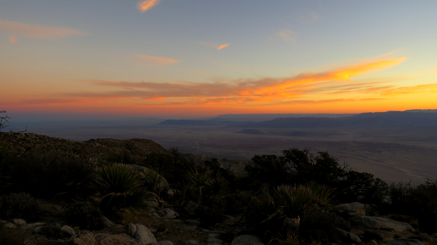
Sunset color from Villager Peak
Since you’re camping, you’ll also get the benefit of watching the sun set from the summit. Watching the evening shadows lengthen across Borrego Valley while the surrounding mountains take on contrast and relief from the sun’s angle is one of the sublime pleasures available on this hike. A dayhike will not grant you ample time to enjoy these handful-in-a-lifetime kind of sunsets and sunrises.

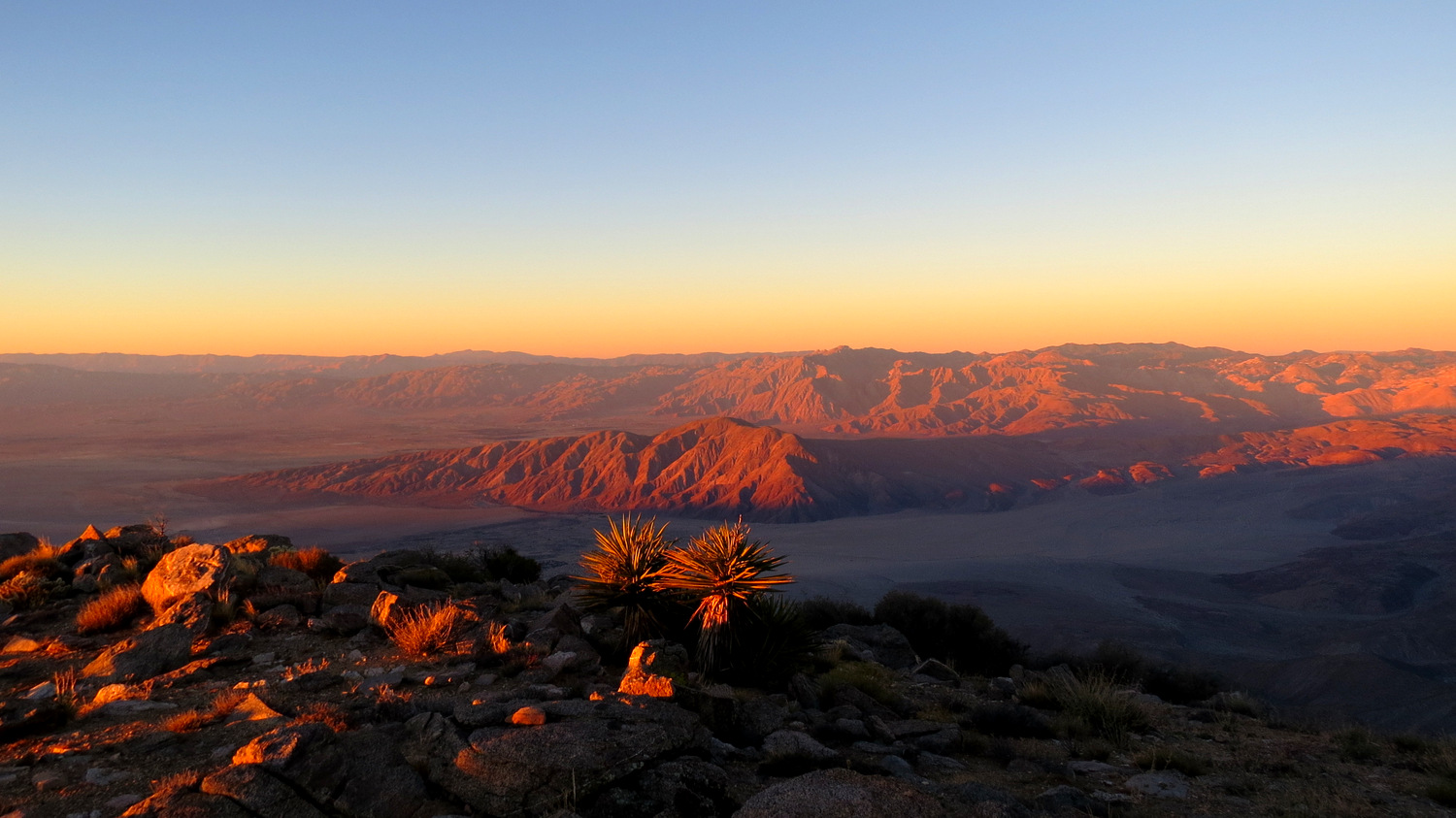
Crimson alpenglow across Borrego Valley

Sun rising over the Orocopia Mountains
For the approach to Rabbit, you’ll wish to get a pre-dawn start if you want to make it to the peak and back, re-pack your gear, and then take the arduous 5000′ descent down from Villager in time to eat a hearty dinner in Borrego Springs. Because you’re backpacking, you can leave the majority of your gear and some of your water behind to lighten your load. Navigation in the dark is a bit tricky, and you will absolutely need a headlamp even if the moon is full. Previous hikers have left reflective cubes attached to trees along the path to help you find your way. You’ll miss them if you aren’t using a headlamp.

Along the crest
Thus begins a rollercoaster of a hike in which you will promptly lose and gain elevation repeatedly as you ascend every undulation in the ridge between Villager and Rabbit. The initial 500′ drop from Villager is followed by several 100-300′ undulations and 600′ ascent to Peak 5859, followed by a 300′ drop and a 200′ climb before you reach the base of Rabbit Peak. From the base of Rabbit Peak, you’ll climb 900′ in a little over .5 mile to reach the flat summit. On your return journey, you’ll do the whole thing in reverse.

Sun rising over the Salton Sea
Somewhere along the way, provided you had a pre-dawn start, you will no doubt notice the sky’s transition from inky, diamond-strewn black to a deep blue with a line of warm color on the eastern horizon. The waters of the Salton Sea will become translucent as the dawn approaches. If it’s cloudy, the clouds will undergo a transition from grey shadows to blood red streaks across the sky. Do your best to be atop one of the ridge’s higher points, because this is a sunrise you will not wish to miss. To the east and north, the sun rises over the Salton Sea. To the south and west, the sun’s first rays cast a violently iridescent alpenglow across the San Ysidro Mountains and Coyote Mountain. As far as sunrises go, there is a fair chance that this could be one of the most memorable you’ll ever experience.

Borrego Valley at dawn
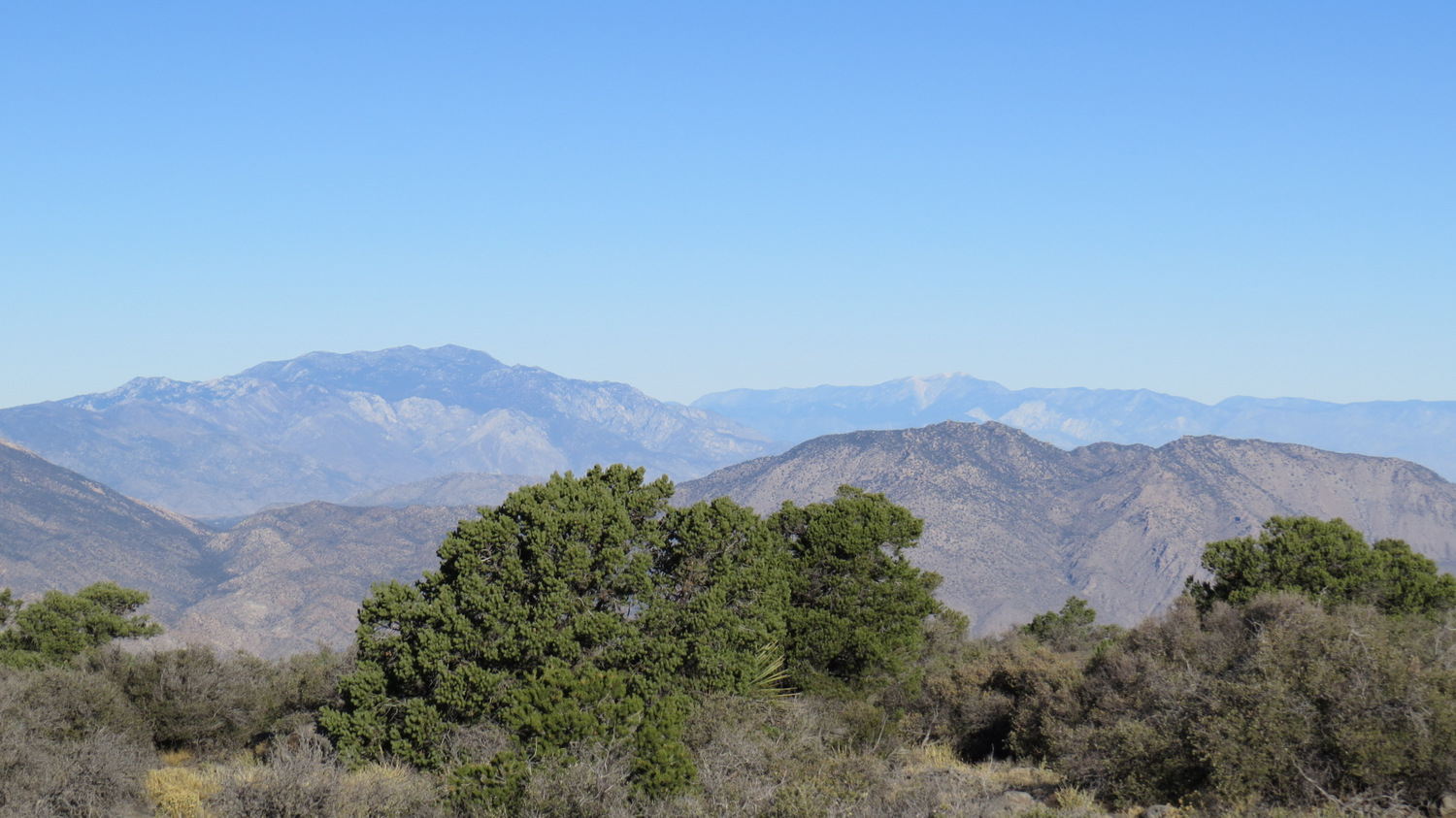
From the base of Rabbit Peak, commence the steep climb up a rocky, sandy slope through a sparse woodland of shade-giving pinyons. This arduous climb will take a lot out of you, and it’s not much easier coming back down. However, the grade will soon flatten out, and you’ll find yourself entering a heavily-wooded flat studded with pinyon pines, scrub oaks, chaparral, and several small meadows. A boulder pile with an ammo canister chained to it marks the summit. You won’t get the same panoramic views as on Villager or even on the ridge, although you will get your first clear looks at San Jacinto and San Gorgonio from the summit boulders.

Rabbit Peak’s summit plateau
The real beauty of Rabbit Peak lies in its “Island in the Sky” nature. Here, you are in a secret world, separate from the rest of Southern California. You will find numerous campsites around the summit, and if you want to get a full sense of the view, you can spend several hours poking around looking for vistas north, south, east, and west. Camping here would be wonderful in many ways, but you will need to assess for yourself whether you wish to carry your full pack over the 10.5 miles and 6600′ of climbing between here and the trailhead. It will make the climb significantly more challenging.

From left to right, Mt. San Jacinto, Mt. San Gorgonio, and Martinez Mountain in the foreground
Whether dayhiking or backpacking, this is your turnaround point. As you’ve probably gathered, you should not underestimate the amount of work you have before you. Not only do you have another 10.5 miles of walking, you also have 2000′ of climbing and 6600′ of elevation loss to contend with, not to mention all of the terrain and pointy-plant challenges you encountered on the way up. While physically easier, the return journey is much more challenging mentally, as you will undoubtedly reach a point when you are ready for it to be over.

Toro Peak with Peak 6582 (Dawn’s Peak) in the foreground
Before long though, you will have collected your gear from Villager Peak, loaded back up, and will have made the painstaking descent back to the desert floor. By the time you finish, you will have conquered one of the most difficult hikes in Southern California, and the sense of accomplishment exceeds that which you get from other challenging hikes. More than that, there is an abundance of moments on this route where you will experience a number of sublime sensations ranging from awe as the sun rises over the Salton Sea, excitement at the sight of meteors streaking across a clear, cold sky, and the mysterious remnants of ancient cultures.
Tags: anza-borrego, Anza-Borrego Desert State Park, Backpacking, Borrego Valley, Cahuilla, Coachella Valley, desert, Rabbit Peak, route finding, salton sea, Santa Rosa Mountains, Sunrise, sunset, Villager Peak