Located in the western San Gabriel Mountains, Mendenhall Peak is named after William V. Mendenhall, a former Angeles National Forest Supervisor who served during the mid-20th century. Rising above Little Tujunga Canyon, hiking to this rarely visited summit is a great way to spend a day in the mountains without too many other people around. While most of the trail is fairly tame, the final mile to the summit is gnarly. Think bushwhacking, light scrambling, and plenty of plants that will draw blood if you come too close. Unless you’re an experienced hiker who is comfortable navigating sketchy terrain, it’s best to leave this final push for another day.

You’ll walk along Fire Road 3N32 for most of the hike.
The trailhead parking is small – only about 5-7 cars can fit. However, you shouldn’t worry too much about finding a place to park, as you likely won’t see many people attempting this hike. There also aren’t any amenities, so make sure you’re fully prepared beforehand. Walk past the white gate on the north side of the highway and head along Fire Road 3N32 to begin your hike.
You’ll immediately start on a steady climb all the way to the peak. Note that this hike is mostly exposed, so it’s best to save it for the cooler months when heat isn’t as much of a concern. At mile 0.4, head right at the junction to continue hiking uphill.

Head right at the junction to continue uphill.

Magic Mountain in the distance.
As you work your way higher, you get increasingly impressive views of the Pacoima Canyon below and the mountain peaks around you. Soon you should have a clear view of Magic Mountain, easily identified by the telecommunication towers built on its summit. If you turn around at mile 1.5, you can see Contract Point and Kagel Mountain. In terms of vegetation, you’ll see lots of chaparral plants, including thick-leaved Yerba Santa and California buckwheat.

The trail snakes its way up to the summit.

Most of the brush was dead when I hiked this trail in the fall.
The trail mostly follows the contours of Mendenhall Ridge’s north face as you snake your way up. Weaving along the mountainside, the San Gabriel Mountains become more visible around each bend. At around mile 2.25, you can see another notable peak, Mount Gleason, straight ahead. Then, about two-tenths of a mile further, you’ll catch your first glimpse of Mendenhall Peak.

Views out into Little Tujunga Canyon and the San Fernando Valley.
At around mile 2.9 you’ll reach Highline Saddle. There is a large transmission tower here as well as audible buzzing from the electricity overhead. You’ll also find an interesting concrete structure housing what appears to be a water pipe. And to your right, you can peer south and into the San Fernando Valley.

The change in scenery helped keep things interesting.
Once you’re ready to continue hiking, head uphill past the white gate. Now significantly higher than when you started, you can see the Santa Susana and Sierra Pelona Mountains to the northwest. The ecosystem also starts to change. At mile 4.25, you start to see some oak and pine trees, giving this section of trail more of an alpine feel. You’ll reach Mendenhall Saddle at mile 4.8. Go right past a rusted gate and make your final push to the summit.

Past this gate, the trail becomes especially harrowing.

This about 45-foot section of trail is very washed out and requires scrambling to traverse.
From here on out, the trail conditions change drastically. You’ll now have to navigate through extremely overgrown trail, including many murderous plants like Chaparral yucca. Pants are recommended for this section. There also are a few chunks of washed-out trail, including a large area at mile 5.5 that requires balance and scrambling to get across. You should only attempt to reach the peak if you’re confident in your bushwhacking and climbing skills. If you choose to press on, at mile 6 you’ll reach Mendenhall Peak, elevation 4636 feet.

I was surprised to find remnants on the summit.

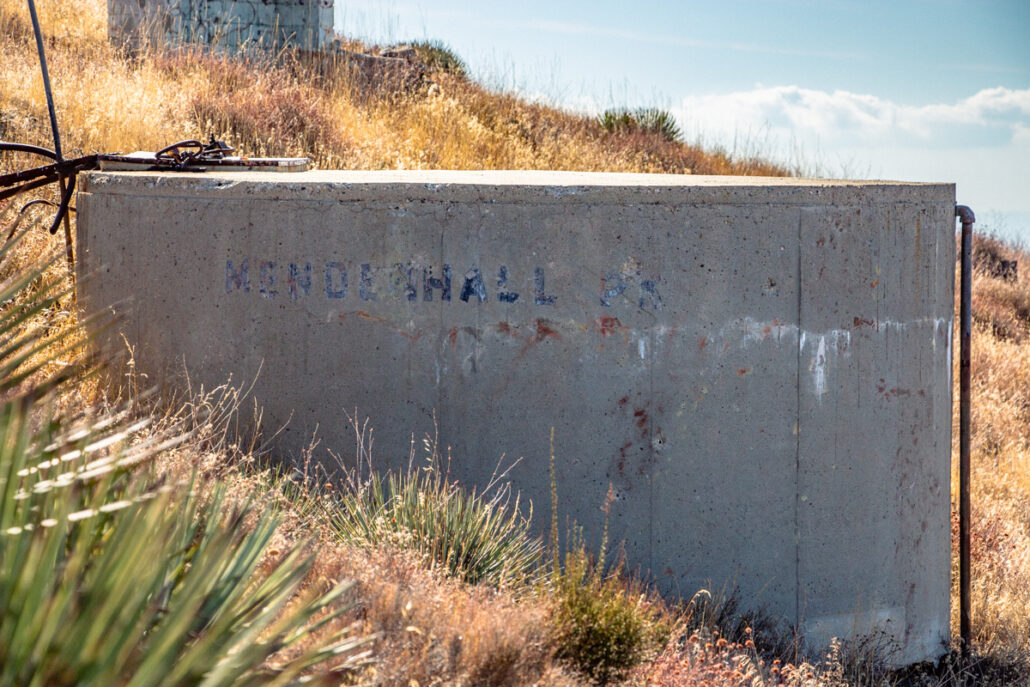
It was interesting to see this “Mendenhall Peak” label on this concrete structure.
At the summit, you’ll find the foundations of an old fire lookout. While most of it is destroyed, you can still explore the several concrete structures still standing, including a set of stairs to nowhere. From the peak, you’ll also have stunning, 360-degree views of the San Gabriel, Santa Susana, and Sierra Pelona Mountains.

Stairs that likely once led to the fire lookout.

Panoramic mountain views.
Head back the way you came to return to your car and complete your hike.

The mountains in the distance were incredible from the summit.

I loved how the afternoon light painted the mountains on my descent.
Tags: Angeles National Forest, bushwhacking, mountains, off-trail, San Gabriel Mountains


