Dozens of people met in El Pueblo de Los Ángeles Historical Monument for the final public comment meeting on the Rim of the Valley Corridor Draft Special Resource Study and Environmental Assessment, the penultimate step in the Study Process that began in 2010 after President George W. Bush signed legislation ordering the study in 2008, authored by Democratic congressman Adam Schiff.
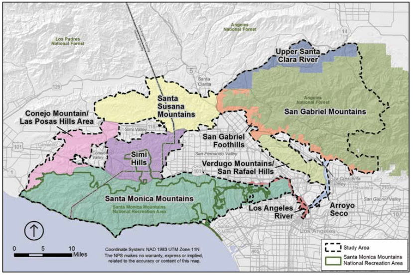
The different regions in the Rim of the Valley Study Area
Similar to the decade-long lead up to the San Gabriel Mountains National Monument, the Study set out to answer four questions concerning a vast area of mountain ranges vaguely circling the San Fernando Valley. The Rim of the Valley Corridor Study Area consisted of 650,000 acres in the Los Angeles Area and included 153,000 acres in the Santa Monica Mountains National Recreation Area and 180,000 acres of National Forest land. 80% of the land in the Study Area is undeveloped and / or already protected open space run by various agencies and conservancies. The Study Area includes regions you might not expect the Park Service to be interested in, like Griffith and Elysian Parks, the Los Angeles River, and the Verdugo Mountains. The centerpiece of the area is the 200-mile long Marge Feinberg Rim of the Valley Trail, which is currently 40% complete.
The four questions the study asked were:
1. Does the area possess nationally significant natural or cultural resources?
2. Is it a suitable and unique addition to the National Park System?
3. Can it be feasibly added to the Park System?
4. Does it require direct NPS management, instead of stewardship from other groups or a public-private combination?
After performing the study (and producing an exhaustive 400+ page report), the Park Service determined that the answers to questions One and Two were a resounding YES. This region contains a very high number of unique, nationally-significant resources including biological, geological, historic, and cultural sites. Indeed, the list of resources is incredibly, almost overwhelmingly diverse. The Study goes into great detail on what makes this region special — including our rare Mediterranean climate, unique and active geology, many endemic species of plants and animals (our ‘South Coast Ecoregion’ supports more than 33% of California’s native plant species in only 8% of the land area. According to the report, there are more endemic plant and animal species in this ecoregion than any other ecoregion in the country!), and our vast collection of historic and cultural sites — ranging from Native American sites and Spanish missions to historic gold and oil fields, exemplary architecture, and important Space Age sites. The Study Area also includes things like the Rose Bowl, motion picture studios, the engineering feats of channelizing the L.A. River (and subsequent planned engineering feats to de-channelize it), and historic downtown Los Angeles, including the Pueblo and the sad but important-to-remember historic sites of the injustices faced by downtown’s African-Americans, Latinos, and Asian-Americans.

Threatened and endangered species in the Study Area. Click for full size.
Question Three is where it gets a little more complicated. The study found that because there is so much overlap with the existing Santa Monica Mountains National Recreation Area both in geography and in natural and cultural resources, it doesn’t necessarily make sense to establish a new unit of the Park System. Instead, they suggested a boundary adjustment for the SMMNRA would be more feasible and allow the Park Service the widest range of tools to facilitate that expansion.
Because the boundary adjustment was thought to be a more suitable proposal for management within the Study Area, the Study did not need to address Question Four.
The Park Service has set four alternatives forward for this study:
Alternative A

- A “No Action” proposal required by all Studies
- Serves as base-line for other proposals
- Maintains status-quo for Santa Monica Mountains National Recreation Area
- No coordination options for broader regional goals
- NPS limited to technical assistance and grant programs for construction of Rim of the Valley Trail outside existing NRA boundaries.
This Alternative basically says “do nothing.” The SMMNRA continues to exist as we know it today, and further expansion of NPS lands would only be allowed inside those boundaries with voluntary landowners and partners (55% of land in the existing NRA boundaries is public land, but only 15% is actually owned by the Park Service). The Park Service will continue to cooperate with public and private landowners to further the mission of the Park but would be extremely limited in what it can offer outside of its boundaries.
Alternative B
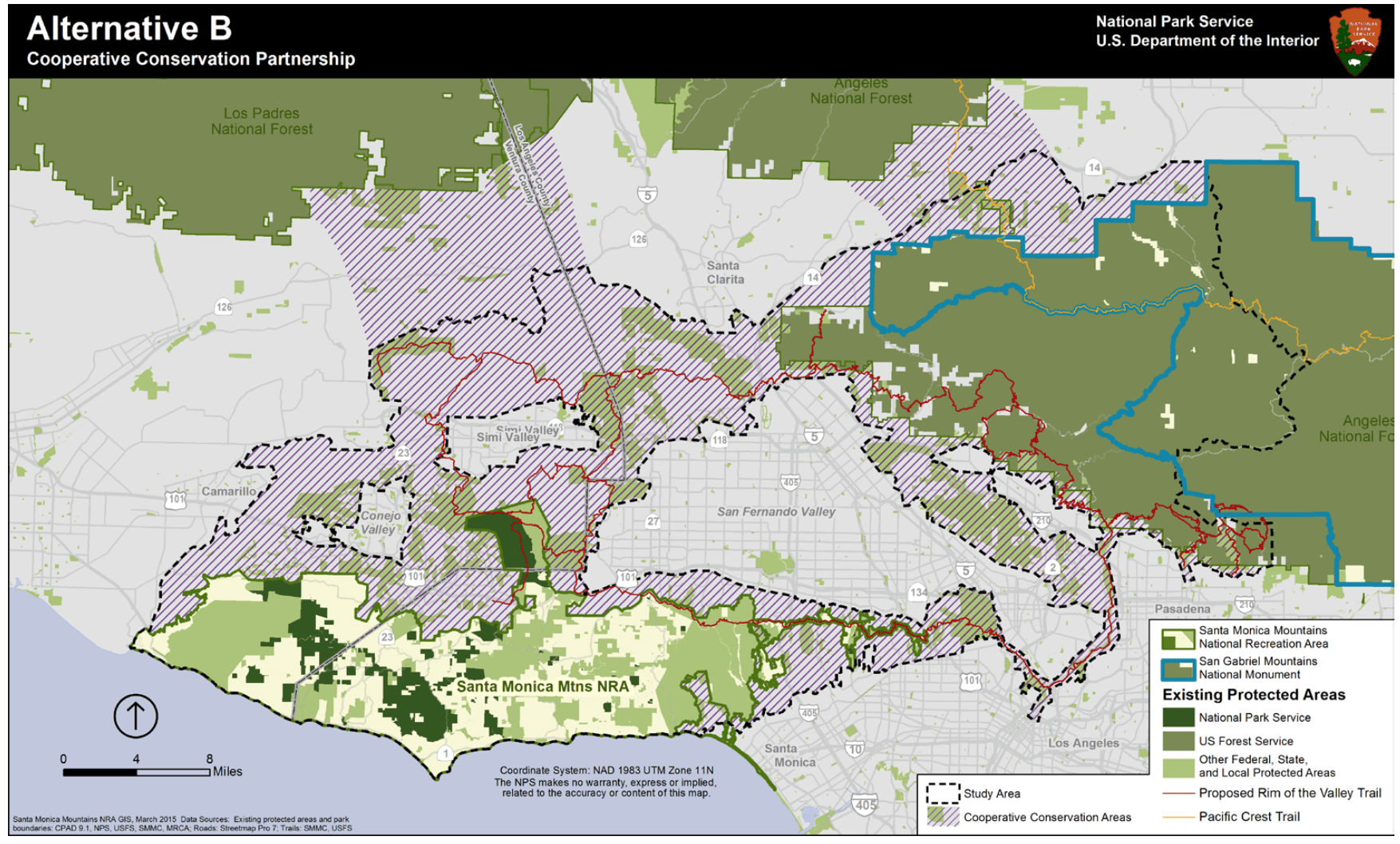
- No boundary adjustment for SMMNRA
- SMMNRA is authorized to engage in cooperative conservation plans in large portions of the Study Area as well as essential wildlife migration corridors between the Santa Susana and Topatopa Mountains in the Los Padres National Forest and between the two separate sections of the Angeles National Forest / San Gabriel Mountains National Monument in the Sierra Pelona
- NPS could facilitate outreach to local communities and provide technical assistance, but could only operate within existing NRA boundaries. Technical assistance includes assistance in resource protection, trail and park planning, and partnership development between agencies, organizations, and landowners — but management and construction remains out of NPS hands
- Federal, state, local, and private landowners voluntarily implement the conservation plan
- Estimated one-time cost of $500,000-700,000 for plan development, staffing, and outreach.
- Depending on level of NPS involvement, additional annual budget costs between $400 and $1 million annually
This Alternative essentially gives the Park Service the green light to develop a regional plan for the Study Area, but limits much of their boots-on-the-ground involvement to the existing Santa Monica Mountains NRA boundaries. They would have the ability to help other agencies implement their plan in the shaded regions of the Study Area, but this Alternative requires other groups to acquire and manage land.
Alternative C
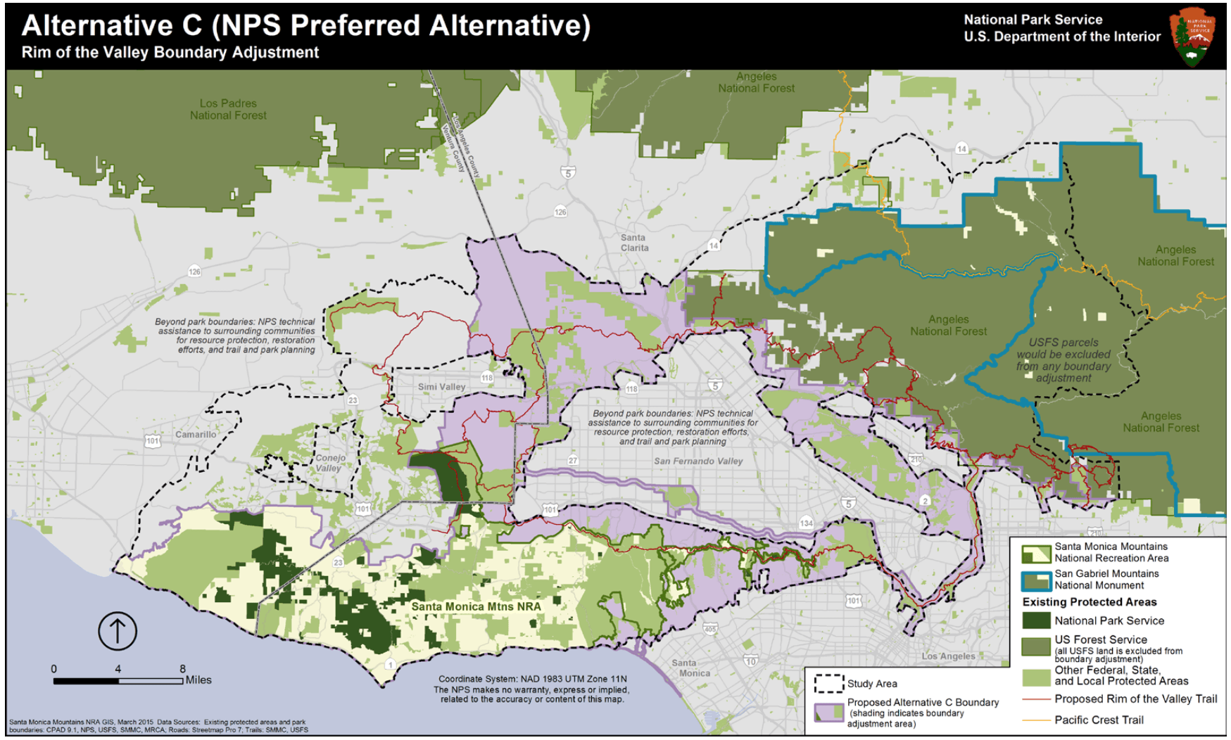
- Expands the boundaries of the National Recreation Area to shaded purple areas, adding 173,000 acres to the Park
- Provides more recreational opportunities to a broad range of urban audiences, many of whom are under-represented in National Parks and underserved by State and local parks
- Provides protection of significant resources and habitat connections
- Includes some of the most heavily populated areas of the Los Angeles region
- Includes Arroyo Seco and Los Angeles River, as well as Griffith and Elysian Parks
- Authorizes the Park Service for all cooperative conservation approaches described in Alternative B in the new borders, but also gives the NPS additional powers to spend funds on resource protection, visitor services, land acquisition, and the planning and development of trails, wayside stations, and interpretive signs within the new boundaries. Also provides broader powers in providing technical assistance to other agencies within the boundaries
- NPS can construct and manage segments of the Rim of the Valley Trail within expanded boundaries, and can also provide more assistance and planning for other agencies building sections of the trail
- Allows NPS to create new trails and facilities within the NRA boundary as well as provide assistance to surrounding communities to enhance access to the NRA and other open space areas with trail connections and transportation options
- Does not expand into Angeles National Forest lands excluded from the San Gabriel Mountains National Monument
- Additional annual operational budget increase of $900,000 – $1.9 million over 2012 budget
Alternative C is the preferred alternative by the Park Service, and in their opinion provides the most “bang for your buck.” This plan focuses primarily on increasing the availability and quality of outdoor recreation opportunities for people in the Los Angeles region and targets those resources at areas and populations traditionally under-served by park agencies. Unlike Alternative B, this Alternative provides the full NPS toolkit for areas inside the expanded NRA boundaries and would allow the region to be run similarly to the way the Santa Monica Mountains NRA is run now — a coalition of federal, state, local, and privately-owned open space and preserves within an existing urban environment. This does not mean that, for instance, Griffith Park would instantly become run by the Park Service — but it does allow the Park Service to provide both technical assistance and expertise for trail, habitat, education, and transportation improvements as well as use Park Service funds to develop those improvements. It essentially makes it easier for the agencies that currently operate these lands to work with the Park Service in realizing a regional system of parks and open spaces with a coherent voice and purpose.
Alternative D

- Further expands boundaries of National Recreation Area, adding 313,000 acres
- All benefits of Alternative C apply to areas within the new NRA boundaries
- In addition, Park Service is authorized to provide benefits of Alternative B in Cooperative Conservation Areas in wildlife corridors shaded with diagonal lines
- Borders encompass the entire Rim of the Valley Trail, allowing the Park Service to be directly involved in its construction and management
- Annual operating budget increase of $1.4 – $3.4 million over 2012 budget
This Alternative is definitely the most ambitious of the four, essentially tripling the size of the National Recreation Area and authorizing the Park Service to form cooperative partnerships in the shaded wildlife corridors outside the official boundaries. It would require a broader use of resources and encounter more complex land jurisdiction than Alternative C, but would further increase outdoor access in the new boundaries.
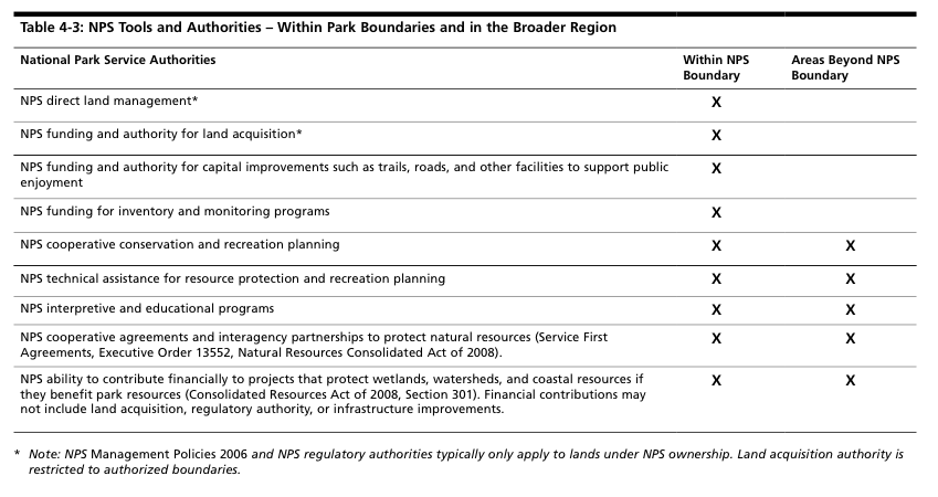
What the NPS can and cannot do in the expanded boundary areas
… and Before Anyone Asks
No, this boundary expansion does not authorize the Park Service to acquire land against the existing landowners’ wishes — including existing parks and conservation areas AND private landowners. Being inside the NRA boundaries also does not put any new restrictions on land ownership or development. If you see anyone complaining about this plan with the tone of it being a “Federal Land Grab,” you can rest assured they have not attended a meeting or read the study.
Questions and Answers
After the NPS staff presented a brief on each Alternative (you can also download an executive summary of the study here), they fielded questions from the audience. Most members of the audience seemed to be very supportive but their questions were usually specific to their neighborhood issues — giving a glimpse, perhaps, as to how complex this project might be.
The vast majority of questions had to do with concerns about additional regulations on lands included in the new NRA boundaries, but the Park Service representatives reiterated that inclusion in the boundary does not immediately add any new regulations or restrictions on top of those that already exist. They may, in certain circumstances, be able to assist other agencies with enforcement of existing regulations via advisement and technical assistance, but if you live in the Hollywood Hills and want to put an expansion on your house you’re not going to see Park Rangers rolling up on your property to ask what you’re up to. Most of the specific questions they couldn’t answer because it’s up to Congress to draft the actual legislation that would put the Study into practice. They did say, however, that while Congress can add more regulations to land ownership, what tends to happen far more often are exemptions from restrictions — especially in complex areas like this.
What Happens Next?
The Park Service has collected hundreds of comments from the public from these meetings, as well as more via mail and email. Public Comments close on June 30, 2015 – you can still leave your comments via a form on their web site. It is important to note that they are looking for your thoughts on specific questions that focus on the mission of the National Recreation Area and the four proposed alternatives.

Dots on the map represent people who came to one of the public meetings
Once the public comments have been compiled, the Final Report will be presented to Congress in late 2015 or early 2016. After that, it is up to Congress to decide what they want to do. It can enact one of the Alternatives in the Study, provide their own plan for the Rim of the Valley, or do nothing. The details will all be worked out in Congressional legislation, so it will be important to remain in contact with your representatives once the Report is submitted to let them know what you would like to see in store for the future of Los Angeles.
Representative Schiff is still serving in Congress and if you live in his district he would definitely be a good person to get in touch with. You can also find your Representative via the House of Representatives web site.
What do We Think?
In my opinion, this is a tremendously exciting time to be involved in the outdoor community here in the Los Angeles region. With the establishment of the San Gabriel Mountains National Monument, Mayor Garcetti’s investments in parks and green space including the revitalization of the L.A. River, and the proposed Rim of the Valley expansion of the Santa Monica Mountains National Recreation Area, it is so refreshing to see Los Angeles realize just how important it is to not only preserve and protect our remaining open space, but to ensure that all Angelenos have good access to it.
The Santa Monica Mountains National Recreation Area is the world’s largest urban national park and has decades of experience navigating the incredibly complex property issues involved with operating a sprawling park near the most densely-populated urban area in the country. With their expertise in interpretive exhibits and visitor experiences — as well as their ongoing partnerships with organizations like California State Parks, the Santa Monica Mountains Conservancy, and Mountains Recreation and Conservation Authority, they are uniquely qualified to provide guidance and support to other park agencies that may not have the resources to provide an optimal park-going experience to users. Alternatives C and D give the Park Service even more tools to improve the green space in Los Angeles and were enthusiastically received by the audiences at the downtown L.A. meeting. Imagine, for instance, Park Service-quality signage and trailheads in Griffith Park or in the Verdugos, or in long-neglected city properties like Rustic Canyon. Or interpretive exhibits that explain how those areas are connected to the L.A. River and Santa Susana and Verdugo Mountains. Or perhaps a new Visitor Center in the Pueblo stocked with information about all the new outdoor opportunities — including the new Marge Feinberg Rim of the Valley Trail — one that, unlike the excellent center at King Gillette Ranch, is accessible without a car.
After the question and answer session at the meeting, we broke into smaller groups to discuss the Alternatives and register our comments. Initially I was on board with the more limited Alternative C. I wanted to make sure that if this expansion happens, people are able to see a drastic and noticeable improvement in outdoor recreation in a short amount of time and felt that the more focused targets of Alternative C could better achieve that goal. However, I was in the minority in my group. Every other person was behind the more ambitious Alternative D and they had a compelling reason for it: this is our shot.
We can learn from the aborted half-step of the San Gabriel Mountains National Monument declaration. Because of a seemingly nonsensical, last-minute boundary that excluded some of the most unique and heavily-used areas of the San Gabriel Mountains, those who wish to see areas like Echo Mountain and Santa Anita Canyon in the Monument now have to continue fighting a steeper uphill battle. If we’re going to go for this, we should go for the biggest, most-ambitious option to protect the most open space, provide the best recreation opportunities for the most people, and help ensure the active wildlife corridors in the region remain open to the animals that need them. There is also not necessarily a need to have the Park Service manage the entire area of Alternative D right away — the legislation can, for instance, include a provision that directs the NPS to focus on the areas in Alternative C first while still providing them with the tools to assist agencies in the larger area in Alternative D if necessary. Many local leaders — including Representative Schiff — have called for a similar combination of the two Alternatives.
Many details still need to be hammered out, but this is not, as the L.A. Daily News’ Susan Shelley writes, “much ado about nothing” — it is an exciting plan to unite L.A.’s fragmented outdoor and cultural experiences into a single, coherent entity that tells the unbelievably unique story of Southern California. I don’t know about you, but that’s a story I’m excited to be a part of.
Tags: draft special resource study, National Park Service, public meetings, rim of the valley, santa monica mountains national recreation area