This week, the Forest Service released the much-anticipated Environmental Analysis of the new Draft Management Plan for the San Gabriel Mountains National Monument, a 199-page in-depth document detailing an environmental assessment of the 346,176-acre Monument designated by President Obama via the Antiquities Act in October of 2014. And on first glance, the new Management Plan seems to be an incredibly forward-thinking document, one that tackles major issues and shortcomings that park managers across the country are facing and that acts in concert with policies already in place at other regional parks, potentially setting a template for other urban wilderness areas in the future.
The draft management plan comes after an extensive public comment period that wrapped up about a year ago. After holding several public meetings across the Los Angeles area and registering online opinions, the Forest Service received more than 900 official comments from groups, agencies, and individuals, which contained over 1,500 individual concerns and comments.
The Forest Service then broke down those comments into four key categories: Transportation and Access, Sustainable Recreation and Use, Social Issues and Environmental Justice, and Wildlife and Sensitive Species Issues. We’ll go over each section below with some of the questions the Forest Service received along with ways they plan on addressing those issues.
Please keep in mind that this document is kind of a huge, sprawling thing chock full of government jargon – so you may want to bookmark this and come back to read it over in sections. Also, although I have now spent a few days (and several cups of strong coffee) going over the draft management plan documentation, it’s not really organized for public consumption so there’s a chance I may have missed something. If you have a question or think you’ve spotted something interesting, share it in the comments and I’ll respond and update the post. The full Draft Plan documentation is available for download here (PDF).
The Draft Plan begins by summarizing the questions asked during the public comment period into those four key categories.
Transportation and Access: The Car Is Not King

crowded parking at a day-use area
The Forest Service asked themselves the following questions at the top of the Transportation section:
- How might the Forest Service provide public access to the Monument for all who wish to enjoy it in a manner that is protective of the objects of interest, that addresses capacity concerns, and that ensures public safety is paramount?
- How might the Forest Service address inadequate parking within popular areas of the Monument?
- How might the Forest Service address dangerous conditions associated with Monument roads being used for night time raceways?
- How might the Forest Service reduce traffic congestion during illegal zip-lining and bungee- jumping from the Bridge to Nowhere and during winter snowfall?
- How might the Forest Service work with surrounding and adjacent communities to reduce traffic congestion concerns in communities that provide ingress and egress to the Monument? (9)
We’ll put aside that interesting bit about the bungee jumping being illegal for now and focus on the transportation issues first, because the San Gabriel Mountains National Monument might have just released the most forward-thinking transportation plan in the entire National Forest system.
If you’ve ever tried to snag a decent parking spot at the trailhead to a popular area like East Fork or Chantry Flat (note: Chantry Flat is not included in the Monument borders), it will come as no surprise to you that parking can sometimes be a major issue in the San Gabriel Mountains. Small trailhead parking areas and narrow, winding access roads can lead to some 405-level traffic jams in certain high-use areas, especially on weekends and holidays. This not only causes frustration with recreators (not to mention a big shot of urban woe into the wilderness experience) but also can create serious safety issues, not to mention degradation of the nearby habitat.
The issue of parking access is not new by any means in Southern California. However, in a region of the country that has somehow come to view a parking space as a Constitutional Right, what’s interesting and extremely progressive of the Forest Service here is the acknowledgment that when you increase infrastructure capacity for cars, all you get is more cars. Case in point: remember Carmageddon, the five-year, $1.1 billion project to widen the 405 through Sepulveda Pass was meant to relieve traffic and reduce travel times? At the end of all that Sturm und Drang, congestion remains and travel times have remained even or actually gotten worse.
While it may seem counterintuitive, the old adage If you build it, they will come holds true with roads and traffic. Reams of studies show that building more car capacity on roads just makes roads more clogged with traffic so it is extremely heartening to read the Forest Service’s desired conditions for the new Monument (emphasis mine):
- The Monument is accessible through alternative transportation and public transportation options in coordination with other agencies and gateway communities to provide greater access for those who do not have personal vehicles, reduce vehicle congestion, address parking capacity issues, and improve public safety.
- Road density within the Monument remains stable or is decreasing. The number of automobiles are reducing over time.
- Roads and trails are maintained to standard. (12-13)
In the Draft Management Plan, the Forest Service outlines a number of approaches to achieve those desired conditions. The Forest Service notes that “currently available funding is insufficient to fully maintain the existing road system” (187), so first of all they plan on focusing those limited road and trail funds on public safety and natural resource protection. After that, improving certain existing roads and trails so that they qualify for additional federal funding to further maintain those routes will help, although additional sources of funding – and perhaps volunteer work – may be needed for both roads and trails. The plan also talks about improving some existing parking areas (for an idea of how these new parking areas might look, plans for an updated recreation area near Cattle Canyon in the East Fork were unveiled earlier this year). But the more forward-thinking aspects of the plan have to deal with making it easier for people without cars to access the Monument.
Most National Forests aren’t as close to a region as heavily developed as the Los Angeles metro area, but it makes total sense for the Forest Service to link up with our already existing (and growing!) mass transit network. Several approaches focus on working with more local governments to provide more and better public transit options to the Monument region, specifically pointing to Metro Gold Line stops as a good starting point. The Fish Canyon shuttle program run by the City of Duarte has been a tremendous success so far, and working with the Foothill Cities to create additional routes from other Gold Line stops seems like a reasonable place to start.
While the Forest Service acknowledges that it may have to increase parking capacity in certain areas, it also highlights managing those areas better by considering temporary closures and one-way traffic flows, enforcing parking capacity limits, and limiting parking in key riparian areas to reduce damage. To this end, the Forest Service also plans on decommissioning what they deem “high-risk, low-value” roads and reducing unauthorized roads and trails to better focus their funding, although the document itself does not say which roads will be rated that way.
And even with all this talk of reducing automobile traffic, there’s no need to worry if you just enjoy driving through the mountains – the Plan acknowledges “driving for pleasure will continue to be a popular activity within the Monument.” (78)
Sustainable Recreation and Use: How to Not Love the Forest to Death

Bathers at the East Fork of the San Gabriel River, one of the most heavily-used areas in the San Gabriel Mountains. Many artificial rock dams are visible in the photo, which adversely affect the river. Photo by Charles White. Used via Creative Commons.
The questions asked of the Forest Service appear on page 10 of the Draft Plan:
- How might the Forest Service align and coordinate its recreation opportunities and system of trails with surrounding communities’ trails and open space networks?
- How might the Forest Service address conflicts between motorized and non-motorized users and conflicts between different types of non-motorized trail users?
- How might the Forest Service address the need for trail system inventory, mapping and characterization, levels of difficulty, variety of opportunities (long distance, beginner, technical, single track, loops for a variety of uses including mountain bikes, hikers and horses) and planning for new trail development and connections?
- How might the Forest Service address the need for long-term road and trail maintenance and restoration, particularly on national recreation trails, including the Silver Moccasin and Gabrielino Trails, those closed previously for resource issues, and those in fire-damaged areas?
- How could the Forest Service address the need to provide meaningful visitor information and environmental education and interpretation programs that are relevant to diverse visitors?
- What are the impacts of concentrated recreational use on streams and riparian areas? How might the Forest Service manage recreational use to protect aquatic resources?
- How might the Forest Service align volunteer and partner contributions to ensure a well- coordinated approach to maintenance of the resource and sustainable land management within the Monument?
In 2011, between 3.6 and 4.2 million people visited the Angeles National Forest, which puts it between the 2016 visitation for Zion National Park on the low end and Yosemite and Rocky Mountain National Parks on the high end. The Draft Plan posits the Monument is the most heavily visited section of the Angeles National Forest (67), which may come as a surprise to frequent hikers at Echo Mountain and Santa Anita Canyon. With the Monument designation, visitation is expected to increase, and much of the Draft Plan offers direction as to how to deal with that influx and ensuring those people have a high-quality experience with their public lands.
The Forest Service’s desired conditions for sustainable recreation are as follows (emphasis mine):
- Recreation opportunities, including products, services, and the built environment, support the needs and expectations of the diverse population in the surrounding area, including urban visitors, youth, people with disabilities, aging populations, and different ethnic groups.
- Youth are engaged in outdoor recreation and conservation education opportunities, fostering the next generation of public land stewards.
- Interpretation materials capture the rich cultural history that shaped the area, including Native Americans, Spanish missionaries and colonialists, Mexican rancheros, Euro- Americans and Asian settlers and prospectors.
- Public outreach and education uses contemporary social media, new technology, and culturally relevant media outlets. Engaging schools, communities, universities, museums, and other educational institutions invested in elevating public awareness of the environment, conservation, and outdoor recreation presents exceptional opportunities to re-imagine Angelenos’ connections to their surrounding forests and open spaces.
- Conservation education focuses on themes of urbanization, fire, heritage resources, and wildlife and plants, which are the main management challenges within the Monument.
- Signs are universal and public information and education is multilingual to ensure communication is intentional, meets information needs, and conveys a message of public access for all.
You may have noticed that the questions asked in this section deal with a variety of different topics, so we’ll just go through them.
First of all, everyone who’s ever used a Forest Service website should be excited about the phrase “(using) contemporary social media, new technology, and culturally relevant media outlets.” I realize the Forest Service is stretched thin and is genuinely doing the best they can – especially with so much of their funding now being diverted to fighting these year-round megafires and being hamstrung by bureaucratic rules – but the Angeles National Forest web site is kind of a mess and has always been kind of a mess. Hopefully this new Plan will give the Forest Service a degree of creative autonomy and allow the Monument to establish a functional (and more importantly, fun) social media and online presence. Their neighbors at the Santa Monica Mountains National Recreation Area have been running an exceptionally colorful and interactive social media presence for several years and should serve as an excellent example. Having a robust social media presence will also help the Forest Service achieve some the other goals it lays out in the Social Issues section.
One important focus in this section is the attention given to the fire burn areas and long-distance trails. The Pacific Crest Trail gets a spotlight on page 14 with some additional guidelines and goals. These include prioritizing the scenic and experiential value of the PCT at all new road and trail crossings, increasing the number of educational and conservation programs about the PCT, and limiting recreation events along the PCT to “designated crossings only” (still not sure what that means, exactly). There was some controversy this year when the long-running endurance run the Angeles Crest 100 had to change its course for the first time in 29 years, and I wonder whether or not these new guidelines may give the race and similar events more trouble in the future. The Document states that “existing recreation events may be allowed to continue at current levels,” (175) however.
The fact that other long distance trails like the Silver Moccasin, Gabrielino, and High Desert National Scenic Recreation Trails get a shout-out for additional love bodes well. Stretches of both the Silver Moccasin and especially the Gabrielino Trails travel through heavily fire-damaged areas and in some cases the trails cannot be legally traveled yet. Here’s hoping an additional focus on these regions and burn zones in general can help rehabilitate and reopen them to the public on an accelerated timeline.
While this section of the draft plan documentation doesn’t specifically address it, the actual Draft Plan itself does mention doing additional research on what they call “visitor capacities” (175). While several people commented on the possibility of visitation limits to the Monument (see What’s Left Out? section below), actual implementation of visitor limits is out of the scope of this Draft Plan. However, the Plan does specifically mention “evaluat(ing) the need for recreation carrying capacity in high use areas such as San Gabriel Canyon” (175). Combine this with their studies into potentially closing off roads or changing the traffic flow during high-visitation, and you can see they’re at least gathering data to see if visitor quotas or shuttle systems will make sense as visitation continues to increase. While systems like these are usually met with a healthy amount of grumbling from veteran users, they generally end up working well in reducing traffic, limiting impact on the natural resources, and can sometimes even make long distance hikes possible without having to organize a car shuttle.
On the topic of conservation education, the San Gabriel Mountains National Monument, like the Santa Monica Mountains NRA, is in a great position for unique interpretive educational opportunities. Not only is it near the most dense urban region in the entire country, but it is also smack dab in the middle of a Mediterranean climate zone — one of only six in the world. Wildfires play an important role in the natural order of the landscape here as well, so it’s heartening to see the Forest Service focusing on urbanization and fire in addition to the usual wildlife and plant topics. Again, the Forest Service has an exemplary role model nearby in looking for partnerships or inspiration in these educational fields — the Natural History Museum of Los Angeles.
In recent years, the Natural History Museum of Los Angeles has really stepped up its efforts to remain relevant to its urban audience and has become a groundbreaking leader in teaching about the urban-wilderness interface. The grounds now house an extensive garden of native plants, a permanent exhibit about wildlife in the city, and is raising funds for a new Urban Nature Research Center. The Museum has led fun and successful citizen-science “bio blitzes” to document wildlife around the city and in the Santa Monica Mountains, and I’m looking forward to seeing what kinds of similar events happen in the San Gabriels.
The new Management Approaches section here goes into detail about different groups and gateway communities the Forest Service needs to work with, but the tone of the Plan really gets summed up in the final part of that last desired condition: conveying a message public access for all. We’ll discuss some of those efforts in the next section.
Social Issues and Environmental Justice: This Land is Your Land

New signs appear in multiple languages
The Social Issues and Environmental Justice has the shortest question section in the Draft Plan, but these are some of the most interesting and challenging questions any outdoor agency is facing right now:
- How could the Forest Service increase access and the ability to enjoy existing opportunities in the Monument for youth and minority populations adjacent to the Monument?
- How could the Forest Service support access to the Monument for underprivileged youth and minority populations?
- How might the Forest Service outreach to differing demographics, such as youth, millennials, and urban populations that may not initially have knowledge of or an interest in visiting the Monument?
The Draft Plan’s structure is a bit confusing once you get to this point, because unlike the Transportation or Sustainable Recreation sections there is no corresponding section of desired conditions or management approaches. Instead, the responses and approaches to these questions seem to be split up and scattered across the entire document and in some cases responses to other categories seem to be responses to these particular questions, which can make tracking down a coherent summary a bit of a challenge.
In terms of access, we’ve already covered some of the Forest Service Plan’s new ideas on making it easier to get to the Monument without a private automobile. Much, much further in the Plan (page 70) we get a bit more on ethnic and racial diversity issues.
Southern California hikers are among the most diverse in the country, and the visitor numbers in the San Gabriels attest to that. The latest visitor demographics (circa 2011) show that 43% of all visitors to the San Gabriel Mountains were non-white (described here as “Hispanic and racial minority visitors.”) Contrast these numbers with the percentage of Hispanic and racial minorities from Los Angeles County (73%) and San Bernardino County (68%) and you can see the Forest Service has a bit of work to do. The Plan acknowledges “There is a notable gap in the number of minorities visiting the Forest compared to the minority population in the counties adjacent to the Forest.” (70)
In 2014 and 2015, researchers found there were several specific areas that had greater proportions of Latino visitors. The percentage of Latino visitors was 40% in the high country and San Gabriel Canyon, and sections of the San Gabriel and San Antonio Canyons were majority (55%) Latino. The draft states:
This information indicates that management actions to meet the needs of diverse visitors should be concentrated in specific areas. This information also indicates that changes to visitor capacity and access in specific locations may have disproportionate impacts to minority populations.
Again, back to the proposed changes to the popular picnic and bathing area along the East Fork. Here, the Forest Service is working toward increasing outreach and inclusion by offering interpretive and regulatory signs in multiple languages (which have already been installed) and by expanding picnic areas to allow for the multi-generational groups that occur more frequently where Latino families recreate outdoors … but the Forest Service also acknowledges that reducing available single car parking in this area will disproportionately affect Latinos.
In terms of outreach to younger generations, the Plan notes the importance of “fostering the next generation of public land stewards” by increasing youth outreach, education, and programs specifically designed to get more young people into the Monument. The Plan makes reference to Last Child in the Woods and quotes former Forest Service Chief Gail Kimbell in 2007:
Our most important resource in this country is not forests, vital as they are. It is not water, although life itself would cease to exist without it. It is people. The challenges of climate change and looming water shortages will not be resolved in a few years. It will take generations. Today’s children—and theirs—will need to be able to take the baton and finish the race. For that, they will need a full understanding of why forests are so valuable, along with a strong land ethic. It is our imperative to give them both.
The document also goes into great depth on concepts like “economics of access” and “social sustainability,” which is extremely refreshing to read in an official management plan. The Plan states, “Many economically disadvantaged populations in the analysis area lack access to existing recreation opportunities due to lack of close-to-home open space, lack of effective transportation, lack of culturally advantageous facilities or opportunities, and lack of knowledge about recreation and natural resources” (94).
Social sustainability is defined as the concept that future generations should have equal or greater access to social resources than the current generation, while also stating that there should be equal access to those resources within the current generational cohort.
There are currently almost 200 miles of open Forest Service roads within the Monument boundary but the issue is getting people to the recreation opportunities from where they live and work. Access to working vehicles to drive to the forest is a barrier to recreation that is experienced by low-income and minority communities. They rely on public transportation but the current public transit routes do not easily connect these communities to the Monument. (94)
The Draft Plan aims to place an
emphasis on outreach to youth and minority populations that may not otherwise have an interest in visiting the Monument. Conservation education and interpretation would be relevant and meaningful to a diverse audience. All of these efforts are a means to improve visitor satisfaction and recreation equity—helping visitors match their desired experiences with opportunities within the Monument. (76)
It’s important to note that these questions are, in many ways, the defining questions of modern outdoor recreation. Park managers across the country are grasping with these issues – as are countless outdoor advocacy organizations and more recently, outdoor retailers. The popular image of an outdoor recreator as an older, relatively affluent Caucasian is simply no longer the truth in many places in America. More diverse and younger audiences are discovering the joys of the outdoors – but in many places they are having to do that on their own because most outdoor agencies and programs are still geared toward that older audience.
It is extremely encouraging to see the Forest Service tackling this issue head-on here, and again, they are in excellent company. Southern California outdoor agencies have in many ways been leading the way on this issue for years, now. The Mountains Recreation and Conservation Authority and Santa Monica Mountains Conservancy regularly lead bilingual programs and offer free shuttle busses from downtown Los Angeles to the Santa Monica Mountains. The staff at the Audubon Center at Debs Park does most of their programs in English and Spanish and many of the staff actually live in the neighborhood of the park itself. The Santa Monica Mountains have been running a highly interactive social media program for years, and San Diego County ‘s Parks and Rec department has recently started producing some very cool virtual hikes online. While outdoor agencies have yet to find “the magic bullet” on these issues, SoCal organizations are trying creative strategies to reach these new audiences, and we are excited to see the Forest Service join in on the action.
History: Walking in the Footprints of Others
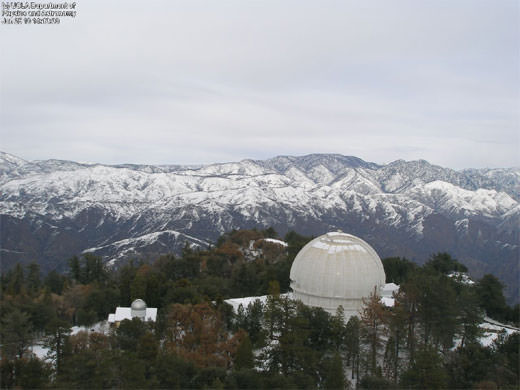
the historic Mount Wilson Observatory
Multi-lingual signs and staff are one way to make the Monument more inclusive. Another way is to acknowledge the rich human history in the San Gabriel Mountains. In the Sustainable Recreation section, one of the aims of the new Plan was to make sure “interpretation materials capture the rich cultural history that shaped the area, including Native Americans, Spanish missionaries and colonialists, Mexican rancheros, Euro- Americans and Asian settlers and prospectors.”
For this Draft Plan, the Forest Service worked with a wide range of local groups to identify historical and cultural resources, including all federally recognized Native American tribes local to the Monument as well as two bands of Gabrielinos who are not yet federally recognized.
A 2015 survey on just 7% of the Monument’s land found about 1000 cultural resources, which the Plan also refers to as “Heritage Resources.” Based on that survey, the Forest Service estimates more than 12,000 resources remain undocumented inside the Monument boundaries (30). Many of the known resources are eligible for inclusion on the National Register of Historic Places, and the Forest Service breaks down its responses to each into four categories: Preservation (cultural and natural resources that are best maintained as-is), Enhancement (sustainable and adaptive reuse buildings, interpretive enhancement, etc), Scientific (resources suitable for research and data collection, and perhaps not suitable for public access), and Release (resources that are not fit for inclusion on the National Register, sites that have been destroyed, etc).
In the initial survey area, 42 sites could be released, while the majority of sites fell under the Preservation Category. Some sites like the Bridge to Nowhere, Mount Wilson Trail, Mount Baldy Trail, and Burkhart Trail could be categorized as Enhancement.
Other notable sites included:
- The Aliso-Arrastre Special Interest Area – a region on the north side of the San Gabriels with extensive archeological sites.
- Eldoradoville – the site of the historic gold-mining boomtown on the East Fork of the San Gabriel River, which was mostly destroyed by the Flood of ’38.
- Mount Wilson Observatory – the site of numerous groundbreaking discoveries and world record-holding telescopes.
- The San Dimas Experimental Forest – a leading field laboratory for the study of chaparral ecology
The report identified three other districts that may also qualify for inclusion on the National Register. The Big Pines Recreation Area near Wrightwood, which was nominated in 2006; Mount Baldy village (which is outside the Monument); and the East Fork Mining District, which was nominated in 1997. Because the East Fork Mining District lies mostly inside the Sheep Mountain Wilderness, the Plan recommends focusing on stabilization of existing structures and research.
As a history-lover, I think it would be phenomenal to see more done to highlight and share the rich and colorful stories of the San Gabriel Mountains. At almost every public meeting I attended during the first public comment period for the Draft Management Plan, one of the requests that came up most often was for NPS-style interpretive displays and historical preservation. I consider myself fairly knowledgeable about the stories of this region, but while I was doing research writing my guidebook Day Hiking Los Angeles , I was shocked to discover just how much I didn’t know. With the input of the Native American tribes and dozens of other groups, we have a chance to learn even more about the amazing tales of the San Gabriel Mountains.
Sensitive Species: What About the Critters?
There is some good news for wildlife lovers in the San Gabriels — despite an insane amount of pressure from changing climate, increased use, and huge wildfires, a 2016 monitoring study found that habitat conditions of the region’s focal species are “stable or improving over time.” (177). The report does dive deep into details about specific species and their areas of concern, but closures due to sensitive habitats remain low.
At Lower Little Rock Creek, most of the OHV areas will be closed. Facilities near Little Rock Reservoir maintain open, however, and the closed OHV areas will be studied to see if there is a potential alternative route that doesn’t hinder the presence of the Arroyo toad. Joshua Tree and Basin Campgrounds are closed here, along with the Santiago OHV route, but all three have potential to be re-opened after analysis.
At the Upper Big Tujunga area, dispersed recreation will continue to be limited by limiting parking access.
In Soledad Canyon, the Wildlife Viewing station will remain, but Soledad Campground will be closed and all of its facilities will be removed.
While several other areas are listed as critical biological land use zones, all existing activities will continue unabated for the time being. Interestingly, the entry for Williamson Rock reads “existing use of the Williamson Rock climbing area is retained” (19). The area has been closed to climbers for more than ten years due to the presence of the endangered Mountain yellow-legged frog in nearby Little Rock Creek. An environmental review is scheduled to begin in 2017, and perhaps its inclusion in this Plan bodes well for climbers.
Mineral Rights: That Old Can o’ Worms

Still from documentary “L.A. Miner” via screenshot
Modern Hiker (and its comment sections) is no stranger to the issue of mineral rights within the San Gabriel Mountains. Although language stating individual prospecting in places like the East Fork of the San Gabriel River has been illegal since 1928, the new Draft Plan makes this abundantly clear.
The Presidential Proclamation establishing the San Gabriel Mountains National Monument withdrew all National Forest System lands within the Monument from mineral and energy resources. This action removes these lands from being subject to Federal mining laws, with the exception of existing rights and the Materials Act of 1947, which allows for the sale of common variety minerals such as sand, gravel, and stone. Therefore, the effects to minerals production and the recreation economy is the same under both alternatives in that the land is already withdrawn from mining. (p. 95)
Earlier in the document, the Plan does expressly acknowledge that this policy is a negative impact on the prospecting community, but in the Draft Plan the Forest Service found it more important to protect the hydrology of the East Fork, as well as the critical habitat of the Santa Ana Sucker.
The ability to mine in the Monument boundaries was an issue raised during scoping. People enjoy recreational prospecting for gold. Prospecting for gold and silver in the area is an activity that connects people to the past. One commenter said, “To me this is not only a hobby or an escape but the root of all that is American.” There is a specific community that values pumice dust mined in the area for the niche market of chinchilla dust. “For many years we have bought material from the Blue Cloud mine to package for bathing chinchillas.” These people value the opportunity to collect minerals from the area and believe that restrictions on mining use will negatively impact this aspect of their well-being. On the other side, some commenters value the untouched outdoors and believe that mining activities create waste and destroy natural resources (e.g., water quality), therefore, mining opportunities negatively impact their well-being. (p. 91)
The Blue Cloud mine is outside of the Monument boundaries, so mining is not affected there.
Additionally, the Plan states that “Mineral and Energy resources exploration and development is not suitable within the Monument, except where valid rights already exist at the time of the Monument proclamation,” and that “the Pacific Crest National Scenic Trail foreground is not suitable for special-use authorizations for new communication sites and wind generation sites.” (177)
What’s Left Out?
As you might imagine, the Forest Service also received many public comments that they are not able to act on as they were outside the scope of the Monument Land Management Plan. Some of the frequently commented-upon items included
- Forest Service-operated shuttles: Many comments suggested the Forest Service operate some form of shuttle service, whether it be on a tram, rail, or bus. The suggestion is “outside the capacity of the Forest Service to provide with current funding and staffing and was therefore considered unfeasible.” However, the Transportation goals of the Plan do urge greater cooperation with regional transit systems, and the Plan states an alternate proposal for transportation “is being developed in coordination with other partner authorities and is being pursued as a part of this planning effort.” (25)
- Bike Infrastructure: “Construction of new bike paths, more recreational facilities, and entrance stations were proposed, but are also outside of the scope.” (26)
- Fee Changes: The Adventure Pass program is reduced and is about to go back into effect, but changes to the fee structure, including increased admissions to help pay for more improvements and trail work, are also not things that can be altered in the Draft Plan. They do state, however, that admission fees “could be considered in a future process focused on such changes.” (26)
- Visitor Limits: A controversial suggestion, but one that is being investigated and even promoted by land managers across the country as more and more visitors are met with full campgrounds, crowded parking lots, and backcountry traffic jams. The document responds: “This type of action is outside the scope of this planning effort, but could be considered in a future site-specific process focused on such changes in specific areas. The proposed action does include a goal to evaluate visitor capacity.” (26)
- High Speed Rail Bans: Another controversial plan may put California’s high speed rail lines directly underneath the new National Monument. There are some significant land-use restrictions that are talked about inside the Draft Plan, but it is not 100% clear whether or not those restrictions would pertain to underground tunnels. From the Plan: “A number of comments suggested that the Forest Service deny the California High Speed Rail application for routes through the Monument as a part of this planning effort. This suggestion is outside of the scope of this planning effort, as special use permits are considered on a case-by- case basis once submitted by applicants.” (26)
What Happens Next?
The Forest Supervisor will decide whether to amend the Forest Plan as proposed in this document, or make adjustments based on input that comes out of the results of the environmental analysis and the next public comment period.
The public comment period kicks off on September 10 with an online webinar (!) and runs through October 4.
WEBINAR: September 10 1-3PM. Register online.
DOWNTOWN LOS ANGELES: September 14 3-8PM. Pico House, 430 Main Street, Los Angeles, CA 90012
SANTA CLARITA: September 15 4-8PM. The Centre. 20880 Centre Point Parkway, Santa Clarita, CA 91350
ARCADIA: September 17 10AM-2PM. Angeles National Forest HQ. 701 Santa Anita Avenue, Arcadia, CA 91006
WRIGHTWOOD: October 4 3:30-7:30PM. Big Pines Lodge. Angeles Crest Highway at Highway 2. Wrightwood, CA 92397
Written and electronic comments will also be accepted until October 17, 2016. Written comments can be mailed to ATTN: National Monument Plan Amendment to Angeles National Forest, 701 N. Santa Anita Avenue, Arcadia, CA 91006 or by fax to 626-574-5235. Electronic comments may be submitted to the Forest Service project site, beginning on the date of the publication in the Times.
Conclusion
It’s important to remember that this Draft Management Plan is not a list of projects that are immediately going to start popping up in the San Gabriels. It’s more of a high-level, philosophical guide and rule book that sets the direction for the new “desired conditions” of the Monument and a set of standards and guidelines for the ways the land managers can achieve those conditions.
In that regard, we think the Draft Management Plan is an incredibly forward-thinking document that tackles some very tough questions facing all outdoor public areas, and not just the ones in the backyard of Los Angeles. It is ambitious, it is inclusive, and it is going to be a lot of work to achieve. Many questions remain, and we hope they are answered or at least asked more directly during the remaining public comment period: Will there be changes to the Pacific Crest Trail? Is there a place for the East Fork prospecting community? What is the official position on Bungee America’s operations at the Bridge to Nowhere? How can citizens get involved to extend the public transportation network? And most importantly, what is the likelihood of funding for these projects without additional fees for users?
That said, the Plan is a tremendous step in the right direction for the San Gabriel Mountains and we are truly excited to start seeing some of these ideas come to fruition from what, in many regards seems to be a newly energized and ambitious Forest Service.
Now, if we could only get some of these improvements over in the excluded Front Range …
UPDATE August 24th, 2016
We spoke with Justin Seastrand at the National Forest and he clarified a few lingering questions that we had on our initial pass of the document.
- The “illegal” bungee jump – Seastrand said that specific language was not intended to be included in the publicly-released document, and was an error on their editor’s part. A more updated version of the plan removes that wording from this section on a new version of the document. He said the Forest Service was “trying to strike a positive working tone” with groups in the San Gabriels.
- PCT’s “dedicated crossings” and recreational events – We got a bit of clarification on some of the items concerning the Pacific Crest Trail, as well. Seastrand said that the Forest Service will continue to issue competitive event permits for the Pacific Crest Trail “on a case by case basis.” For events like the AC100, the idea is that the Forest Service would try to minimize the use of the PCT itself, so that the trail’s characteristics are maintained primarily for the backpacking and hiking crowds. It doesn’t mean no events will be allowed on the PCT, it just means the Forest Service would try to utilize other routes where possible. Seastrand also stressed that this language was to be considered a guideline, which gives the agency more flexibility as to what they can allow on the PCT.
- Monument Metrics – A few other outdoor organizations read the management plan and wondered where the metrics were? Lots of good ideas and goals, they said, but how will the Forest Service measure things to know whether or not they’re achieving those goals? Seastrand told Modern Hiker that the mechanics for metrics are actually located in a separate Monitoring Document, the most recent version of which was updated July 8, 2016. Seastrand said the Monitoring section of the Land Management plan covers both the Angeles National Forest and the San Gabriel Mountains National Monument, and provides framework for new goals (such as adjusting to climate change and whether or not to replant conifers after wildfires) as well as a structure for reporting on those goals every two years.
Tags: draft management plan, public comment, san gabriel mountains national monument