On the afternoon of Saturday, September 10th, the Angeles National Forest held a webinar to discuss the recently-released management plan for the San Gabriel Mountains National Monument. The 90-ish minute presentation was well-structured and informative, and also allowed participants to ask questions to the Forest Service staff via a moderator. In the interest of clarity, we’ll include some of those questions inline where they’re relevant and cover the other ones at the end of the summary.
Supervisor Jeffrey Vail approached the virtual podium first, thanking everyone for joining in on the webinar (and staying inside on a beautiful weekend day). Vail first went over a quick summarized timeline of how we got to this stage in the National Monument process and then handed the mic over to Adrienne Dunfee, the Deputy Monument Manager.
 Dunfee gave a bit more on the foundation of the Monument, as well as some background on the draft management plan and the purposes of these public meetings. The draft plan is a government document, so it’s fairly dense and full of some very technical terms, so the first thing she did was clear up some misconceptions about the differences between Plans and Projects.
Plans, like the draft Monument plan under discussion, are “big picture frameworks,” she said. They provide high-level, big picture overviews for the direction of the Monument’s future Projects, which she described as “moving rocks and dirt.” Dunfee also noted that the comments on the Plan would help the Forest Service determine what sorts of Projects they would undertake in the future — and that those specific Projects would also have their own individual comment periods as well.
More vocabulary followed. “Desired conditions” are the description of characteristics the Forest Service will use to guide management plans, while “Objectives” are the measurable and time-specific measurements of progress toward those conditions. She also spelled out the difference between Standards, which are mandatory constraints, and Guidelines, which are similarly constraints for projects or activities but can be a bit more flexible in their implementation.
With that very basic groundwork laid, Dunfee outlined the four key issues in the Monument Plan and said the remainder of the webinar and the following public meetings would focus on these:
- Transportation and Access
- Sustainable Recreation and Use
- Social and Environmental Justice
- Sensitive and Endangered Species
With that, Dunfee invited a speaker for each of the four key areas to take charge of the slideshow.
Transportation
First up was Sonja Bergdahl, the Acting Deputy Forest Supervisor who is normally the forest and monument Engineer. Bergdahl spoke about the Monument’s Transportation Plan, which is one of the most exciting parts of the draft plan — especially for those of us who are frustrated with crowded trailhead parking and who may want to access the Monument without having to get into a car.
“Currently, we have areas that are really over-used,” Bergdahl began. “Cars are parked every which way in turnouts and double-parked. It’s crowded and it’s restricting emergency vehicles, impacts the resources, and affects our recreational experience … but we also have areas that are under-used.”
Bergdahl went into the metrics of the current transportation options in the San Gabriel Mountains, including the more than 1000 miles of Forest Service roads (600 of which are dirt roads), and the extensive trail networks.

Overview of the transportation system in the San Gabriel Mountains. Click to enlarge.
On this map, gold lines are the current State and County roads. Blue lines are the existing Forest Service roads, purple lines are the major trail networks. Red dots are the portals that provide entry and access to the Monument, and the diamonds are the Metro Gold Line stops closest to the Monument itself.
Bergdahl spoke about the need to investigate current Forest Service roads, with an eye to discontinuing their use or turning them into trails not meant for vehicles. She also noted that the majority of the trail network in the San Gabriels does not currently connect with either local trail networks outside of the Forest Service’s jurisdiction or with public transportation, both of which she described as “a huge opportunity to further our connection with the surrounding community.”
The highlighted Gold Line stops – Arcadia, Duarte, and Azusa – could “provide an incredible opportunity for alternative transportation to the Monument.” A seasonal shuttle to the Fish Canyon trailhead from the Gold Line was very successful this year, and the Forest Service will be investigating a pilot shuttle from the Arcadia stop to Chantry Flat beginning on National Public Lands Day this year.
The desire, she said, is to have a Monument that is accessible to those who do not have a car or do not want to use a car, to reduce vehicle congestion, address parking issues, and improve overall safety. The Plan calls for road density to remain the same or decrease, and to reduce the overall amount of automobile traffic in the Monument, while also “maintain(ing) an awareness that driving for pleasure will remain an important use.”
Sustainable Recreation
Forest / Monument Landscape Architect Jose Henriquez took the reins for the Sustainable Recreation section, which can basically be summed up in two of the slides he presented.
How can we encourage and maintain this …
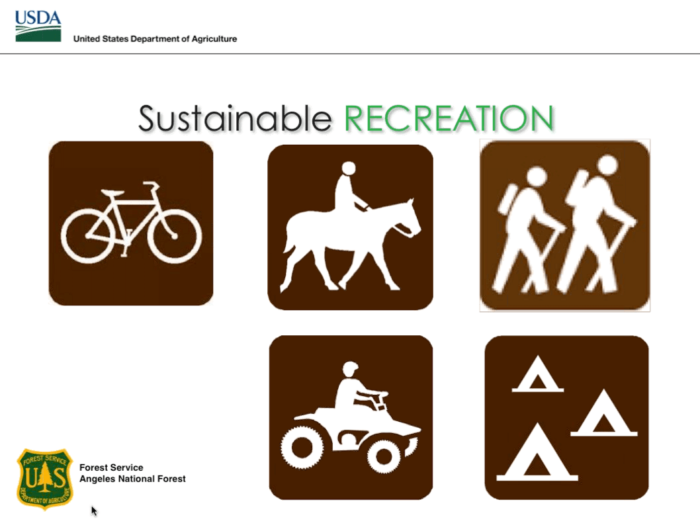

A huge part of sustainable recreation, Henriquez said, is recreation itself. He noted that the current recreational offerings in the San Gabriel Mountains will not change based on this Management Plan, but that one of the Forest Service’s chief challenges here was how to provide a meaningful outdoor experience to millions of visitors while at the same time encouraging responsible use.
Modern Hiker chimed in with a question here, asking Are there any concrete ideas for allowing increased use while instilling conservation values? More rangers on the trail? Informational kiosks? Encouraging funnelling new visitors through established visitor centers?
The Forest Service responded with a bit of Planning inception. Inside this plan, they said, is a commitment to create another Conservation and Education plan. This issue and balance is so important to the future of the San Gabriels — and really, outdoor recreation as a whole — that it’s worthy of its own more focused outline and criteria. Increasing conservation education is most definitely a part of this plan, and they said the Monument has allowed the Forest Service to establish a Field Ranger program to get more rangers on the trails and increase visibility of the Forest Service. He mentioned that funding has increased and that they do hope to increase the access and availability to existing Visitor Centers.
Social and Environmental Justice
 For the Social and Environmental Justice section, Environmental Coordinator and new Recreation and Lands Officer Justin Seastrand stepped in.
Socio-Environmental Justice was one of the primary goals included in President Obama’s proclamation establishing the National Monument. Seastrand said the Forest Service has to ask itself what the people’s relationship to the National Monument is, and that they had to ensure their actions don’t have any undue impacts on minority and low-income populations.
In his speech, Obama said “You have to be able to get to the Monument to enjoy it,” and Seastrand acknowledged this is not currently an easy task for many people who live in Los Angeles County. A significant number of the public comments on the Monument so far, he said, have dealt with this access issue, specifically calling for increased access for younger, more diverse audiences than are traditionally served by outdoor recreation.
In our previous analysis of the Plan, we noted that the Los Angeles region in general is doing a very good job in this. We have one of the most diverse populations in the entire country, and in many ways the problems and issues L.A.-area parks are facing now (and have faced for years already) are the ones the rest of the country is going to be facing in the next 10-20 years. We hoped that the Forest Service would look to other outdoor agencies for inspiration, and it sounds like they will be taking some of those cues to modernize the Angeles National Forest and San Gabriel Mountains National Monument.
This key issue, Seastrand said, is primarily about fairness. “Everyone owns the Monument and everyone should have the option to visit it,” he said. Seastrand said the Forest Service has to help people overcome economic and transportation barriers in order to achieve these goals, and he went on to emphasize that the San Gabriels should not only hold on to their existing user base, but also needs to welcome new visitors as well.
Seastrand echoed some of the transportation issues Bergdahl brought up, and mentioned that in addition to those Transportation solutions, the Forest Service should increase its interpretive duties in the mountains, incorporating the rich natural and cultural history of the region and delivering that message through contemporary methods, including multi-lingual signs and electronic and social media. “We want the National Monument on Facebook and Twitter,” he said.
A participant asked a question about multilingual signs here, and Seastrand used the opportunity to note that the Forest Service is already making progress on this issue in some high use areas. Back in January, we reported on some proposed changes coming to the heavily-used picnic and day-use areas near the East Fork of the San Gabriel River, and Seastrand said that the Oaks Picnic Area already has multi-lingual signs, along with other improvements geared that region’s specific user group.
Sensitive Species and Habitats
President Obama called the San Gabriels an “Island of Green” in his proclamation, and Forest / Monument Wildlife Biologist Nathan Sill spoke about the incredible diversity of wildlife and terrain in the San Gabriel Mountains.
These mountains, he said, don’t just offer recreational opportunities, but they also offer habitat for many native and endemic species as well as wildlife corridors for species that move between regions at different seasons or life stages – highlighting bald eagles, bighorn sheep, and the Santa Ana sucker as specific examples.

The Monument has a wide range of ecosystems, he said, ranging from high montane habitats that may become even more critical for species with a warming climate, to high elevation lakes, mixed conifer forests, hardwood forests, oak woodlands, desert habitats, chaparral, and riparian communities (Sill also noted that statewide, California has lost between 70 and 90 percent of its riparian habitats).
This key issue is another area where the Forest Service has to walk a bit of a tightrope — Sill noted the Monument Plan has established “desired conditions” for these species that ensures their habitat is either stable or improving over time, and that meant that in certain areas they may have to alter the recreational uses to preserve these species.
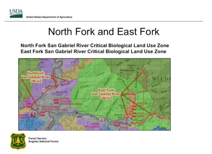
Sill talked about the Plan’s “Critical Biological Land Use Zones,” which he described as “for species that are really on the edge.” There are three such zones in the new Monument – one in Aliso Canyon for the California red-legged frog, and two in the San Gabriel River for the Santa Ana Sucker – one in the North Fork and one in the East Fork. (Zones are shaded red in the maps below)

Sill noted that the Forest Service was specifically charged with protecting and conserving these species in the proclamation itself, which is one of the reasons that all land in the Monument has been withdrawn from new mineral claims. Although some minor restrictions have already been put in place in a few of these areas, Sill clarified that future restrictions may be put in place depending on the needs of the resource.
A participant asked Sill what was being done to protect Bald Eagles and he used the opportunity to give a hypothetical change in the Monument. He said one of the ways they could protect the existing populations, which tend to congregate in San Gabriel Canyon, would be to establish buffer zones around traditional nesting sites so the public doesn’t get close enough to negatively affect nesting behaviors. He mentioned potentially removing some parking areas close to the nests and moving them further away, so that photographers and birdwatchers could still enjoy the view from a distance.
Next Steps / Get Involved
Adrienne Dunfee returned to wrap up the meeting, pointing out the next steps in the remaining timeline.
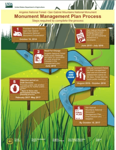 After the public comment period closes on October 17, 2016, the Forest Service will respond to the comments. She said there won’t always be a change to the Plan, but there should be a rationale for why the Forest Service chose to act on your suggestion or not.
A revised Plan will be finalized and published by February, 2017, after which there will be an Objection Period open to those who participated in the planning process (NOTE: We asked what exactly constitutes “participating in the planning process,” and the Forest Service said basically as long as you were engaged in some way during the planning process, you had the option to raise objections — so if you’re reading the Plan for the first time in 2017, you’re out of luck).
A final decision and adoption of the Plan will be made by October 10th, 2017.
There are four in-person Public Meetings on this Plan in the coming weeks
DOWNTOWN LOS ANGELES: September 14 3-8PM. Pico House, 430 Main Street, Los Angeles, CA 90012
SANTA CLARITA: September 15 4-8PM. The Centre. 20880 Centre Point Parkway, Santa Clarita, CA 91350
ARCADIA: September 17 10AM-2PM. Angeles National Forest HQ. 701 Santa Anita Avenue, Arcadia, CA 91006
WRIGHTWOOD: October 4 3:30-7:30PM. Big Pines Lodge. Angeles Crest Highway at Highway 2. Wrightwood, CA 92397
You can also register an electronic comment, read additional documentation, and even view this webinar (including optional English and Spanish subtitles) on the Forest Service’s official page dedicated to the San Gabriel Mountains Management Plan. Written comments can be mailed or delivered in person to ATTN: National Monument Plan Amendment to Angeles National Forest, 701 N. Santa Anita Avenue, Arcadia, CA 91006 or by fax to 626-574-5235. ALL COMMENTS MUST BE RECEIVED NO LATER THAN OCTOBER 17, 2016.
Supervisor Vail closed out the presentation thanking everyone for the questions. “I’d like to emphasize as well that this mountain range has been a National Forest since 1892,” he said, “So while we’re excited to build a new plan to take us into the future, we are taking the long view when looking at the resources. Our charge is to protect and preserve the objects of interest as well as the habitat — it’s a simple directive but not an easy one.”
Seastrand chimed in again, highlighting the importance of the public comment period as a way for the Forest Service to hear new ideas and challenges, and also as a way to get people engaged with the Mountains and hopefully maintain that engagement. “We want to encourage everyone to consider this not as a one-time opportunity,” he said. “These lands belong to all of you.”
Questions and Answers
Following is a rough transcript of webinar participant questions and their accompanying answers from the Forest Service. Where I could, I noted who responded to each question. Responses are summarized and not direct quotes unless specifically quoted.
Q: Are you including nature and interpretation trails in sustainable recreation? The M needs more trails to educate its visitors.
A: We are! We’re trying to add as many interpretive signs as possible on trails – a new interpretive trail is proposed for the Cattle Canyon area in East Fork and we think interpretive trails are an effective way to help instill conservation values in our users.
Q: Are a lot more bear-proof trash receptacles in your vision for the future?
A: (Sill) – We are coordinating with state offices to increase bear-proof storage lockers as well as trash bins throughout the San Gabriels.
Q: Will Monument status change any plans or projects related to waterways or flows?
A: (Sill) – The Monument designation doesn’t change any regulated flows in and of itself, nor water rights. Those are valid and existing rights and won’t change.
Q: What types of recreation will be eliminated from Areas of Critical biological concerns?
A: (Vail) – Existing uses are expected to continue at the outcome of the Plan, but we’ll have to look at the areas on a case by case basis to see if there are any activities that are adversely affecting the species of concern. We would have to consider – with public involvement – whether or not existing use would have to change.
Q: How does the plan improve monitoring and protection of identified endangered species?
A: (Sill) – The plan in and of itself doesn’t specify additional monitoring. We currently work with partners at USGS and Fish and Wildlife to monitor habitats. We already have a robust monitoring program that will continue. In terms of protection, we will carry all of our existing standards and guidelines from the 2006 plan forward into new Monument Plan, as well as establishing new CBLUZs for threatened species. Every time we implement a project, we go through an analysis to see how that project would affect threatened or endangered species. At that time, we’d coordinate with US Fish and Wildlife service on any impacts we expect.
Q: How will human abuse of North Fork of the San Gabriel River affect CA-39 near roadway affect plans? Looks like it will be difficult here.
A: (Seastrand) – The answer to that would be through site-specific projects and guidelines. We’ve agreed to use a National Visitor Use strategy to help guide site specific review of particular areas. Seastrand acknowledged the potential to close certain parking areas and move them to other locations, but there is nothing specifically in this overall Plan that would change.
A: (Sill) – In addition to what Justin said, we also need a conservation education component to these sorts of situations so people have a better idea of how their use and enjoyment of the land affects the species that live there.
A: (Bergdahl) – We have also entered into agreement (with a watershed group – didn’t get the name) to look at holistic analysis of entire San Gabriel Canyon to really look at resources and figure out how to provide recreation and protect resources and improve the public experience.
Q: Are there any opportunities or increased funding for volunteers to help remove invasive species? Will the Monument designation help with additional funding?
A: (Vail) – Yes, there are tremendous amount of opportunities. There are currently hundreds of volunteers operating within the monument right now, and last year we hired a full time volunteer coordinator to improve volunteer efforts. There is a particular emphasis working with five different youth conservation crews that has been very effective so far, and we envision a more robust volunteer program moving forward.
Q: Does this plan address overcrowding during holiday weekends?
A: We are moving toward alternative transportation systems. There won’t be a quick fix for this, but we are looking at future projects to shift use to areas where we have additional capacity.
Q: Will users be included in discussion of transition from roads to trails?
A: (Bergdahl) – Absolutely.
Q: What if the rest of the San Gabriels become part of the Monument? Do we have to do this all over again?
A: (Vail) – There is always a possibility of expanding the monument. Any legislation that might be enacted by congress or another proclamation by this or a future president, we would have to abide by the terms of that. If the legislation or proclamation directed us to go through another management process analysis, we would have to do that. For now, though, we are focused on successfully managing this existing monument and completing the plan within the 3 year timeline.
Q: Once the plan is finalized, when we will get another chance to comment on how things are working?
A: (Dunfee) – This is a plan. You will see follow up on specific projects that follow, which are all subject to an environmental assessment and all of which will have opportunities to provide public comments. Please don’t feel that this is the only opportunity to make your voice heard.
Q: Will there be more shuttle opportunities in the Forest?
A: (Bergdahl) – Great question – thats our dream! We are going to have to rely on our partners for that. We cannot operate shuttle services on our own so we’re hoping in collaboration with cities, Caltrans, and Los Angeles County that we can support each other for grant opportunities. We’re working with SCAG (Southern California Association of Governments) – on a pilot shuttle program that is starting on Sept. 24th and running for 3 weekends through Monument Anniversary Celebration on Oct. 9th. Hoping that this spurs discussion and support for shuttle systems in the future. Azusa, Arcadia, and Duarte are our dream locations to launch more shuttles into the Mountains.
Tags: public comment period, San Gabriel Mountains National Monument management plan