Google Earth is a great program. You can use for anything from casual sightseeing, browsing a hike, or spying on your neighbors. Now it’s also being used as a visceral visual aid for a continuing environmental tragedy that somehow continues to go unnoticed.
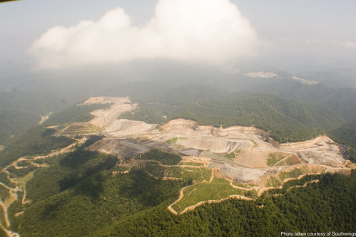
“Mountaintop Removal” is the surprisingly accurate name for a popular type of mining in Appalachia. Basically, to get at coal veins, the top of a mountain is deforested and exploded, with the debris pushed into neighboring valleys. The coal is processed, leaving huge lakes of toxic slurry behind, and then the mine operators plant some non-native vegetation and move on to the next mountain.
Obviously, this causes some problems. Deforestation increases the risk of landslides, and several slurry ponds have burst through their dams or through old mine shafts, wreaking havoc on the communities below them. The 2000 Martin County Sludge Spill contaminated the drinking water of 27,000 people and was 30 times larger than the Exxon Valez spill.
As the push for “clean” coal escalates in the coming years, mountaintop removal is likely to increase … unless more people know about it. And that’s where Google Earth comes in.
I Love Mountains hosts a comprehensive Google Earth “Memorial For the Mountains,” which shows the mountains before and after mountaintop removal mining began. It’s also got detailed information on each mountain, written by local residents, maps of all the sludge dams in the mountains, and an overlay of the larger mining sites on top of major cities — so us urbanites can get a good idea of just how huge these things are. Here’s one of the mines nearly covering the entire island of Manhattan:

Pretty crazy, eh?
And if Google Earth doesn’t float your boat, they’ve also got some Flickr pools of photographic evidence:
Tags: Environmentalism, Politics