Special thanks to Jeff and Nicole for letting me tag along and allowing me to slip a few shots of you guys.
Note: In case you’re wondering why my GPS track is drunk, the narrow canyon made it impossible to get a clean track.
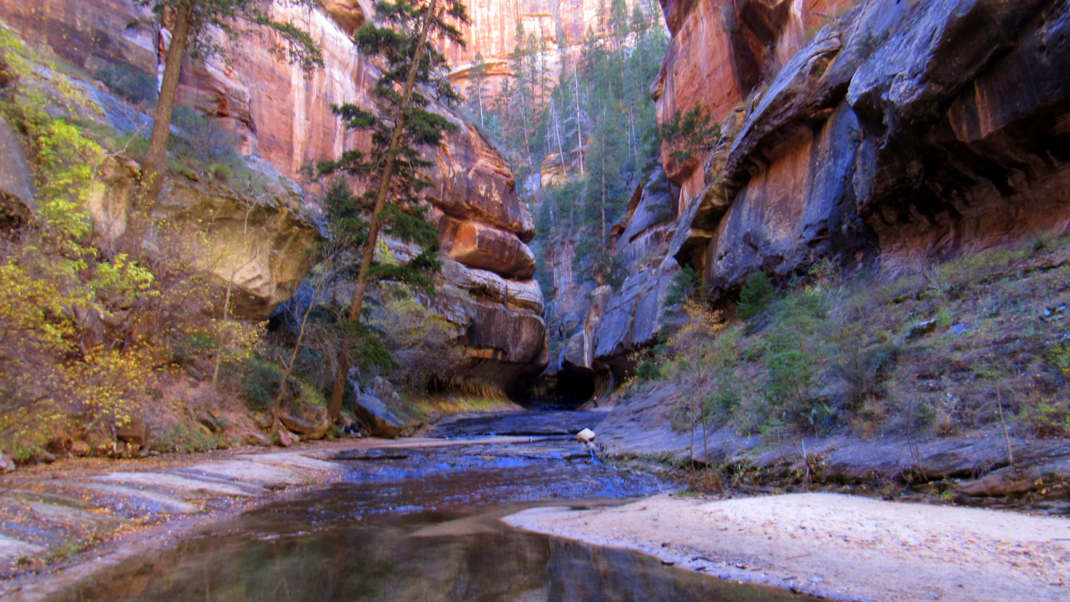
Deep within the crease of the Left Fork of North Creek, the canyon walls converge briefly into a spectacular, twisting slot canyon. Periodic flash flooding over the eons blasted through this bottleneck, gouging out convex recesses at the base of both sides of the canyon wall while carving out several cavities in the canyon floor. The resulting formation resembles a subway tunnel, and the combination of unusual geology, evocative light, and running water attracts canyoneers, hikers, and photographers from around the world.

After the Narrows and Angels Landing, the Subway is one of the most sought-after hikes in Zion National Park. Demand for the hike is so high that the park has instituted a seasonal lottery system to determine which lucky souls obtain one of the 60 permits (https://www.nps.gov/zion/planyourvisit/subwaypermits.htm) available each day. This permit system helps to minimize traffic on the unofficial trail to the route which follows sensitive creek-side habitat from start to finish.

To get your permit between the months of April and October (the most popular times), you must enter the online advance lottery (https://zionpermits.nps.gov/lotteryapply.cfm). Applicants can select three possible dates for the hike on their application, which will include a $5 application fee. After the park conducts the lottery drawing, they will contact you about the status of your application.

If you don’t win the lottery, you can apply for a last-minute permit within a brief window that runs two to seven days before the day you wish to hike. Last-minute permits only become available if permits remain from the first lottery. If no permits are claimed in this way, walk-up permits may be available.
From November to March, you can obtain a permit by reserving online or possibly even by coming in for a walk-up (especially during the week). However, be warned that the water temperatures get pretty cold during the winter and late fall; you’ll find out why this is so important in a bit. Additionally, the road up to the Left Fork Trailhead may not always be open due to inclement weather.
If you do manage to reserve a permit, there remains one final step. On the day before or day of your hike, you will need to go to the Wilderness Desk within the Zion Visitor Center to obtain your actual permit and parking pass. The hours for the Wilderness Desk vary by season (https://www.nps.gov/zion/planyourvisit/upload/lg-hours-10-15-16.pdf), and it is in your best interest to get your permit as early as possible. Lines build up quickly before the office even opens, and the desk remains busy throughout the day due to all of the other permit hikes and canyoneering routes the desk services. Each permit takes about 10 minutes to process (by my informal reckoning while I stood in line), and with the lines routinely reaching 30 groups deep, that is a lot of time to spend in Zion not hiking.

Before we get to the actual hike description, there are a few other factors to keep in mind with this hike. The route to the Subway follows the course of Left Fork North Creek often within the creek itself. An informal trail hopscotches from the left to right bank of the creek and sometimes right down the middle whenever the terrain on either side forbids walking. So, forget about keeping your feet dry and let your inner puddle-stomper shine. Strategies for walking through water may include getting waterproof shoes, special shoes available through local outfitters designed specifically for this sort of thing, or lightweight water shoes, sandals, or trail runners that will dry off quickly when wet. Also, neoprene socks reflect body heat back into your feet which will help keep your feet warm. Personally, I didn’t find the water temperature to be that bad (albeit during an unusually warm November day), and I did just fine wearing wool socks and trail runners.

Flash-flooding can also be a major concern. Every year from July to early September, a configuration of high pressure shunts tropical moisture from the Gulf of California into the Four Corners region, creating the southwest monsoon. Summer thunderstorms can produce intense, localized deluges that drop prodigious amounts of water in a short period of time. The slick rock sandstone that characterizes the region does not absorb this water. When the water runs off in high volumes, it finds its way into the region’s intricate canyon system. If you are in the Subway during one of these times, a flash flood could ruin your hike (not to mention ending your life) without a moment’s notice. Should you encounter flash flood conditions, retreat to high ground. Better yet, if thunderstorms are in the forecast, don’t do the hike at all.
Spring run-off from the winter snowpack can also produce a much higher volume of water as well as much colder water temps. The park tracks the flow and temperature of most watercourses where hikers and canyoneers visit, and it’s a good idea to check ahead with the wilderness desk to make sure conditions aren’t hazardous before you start.

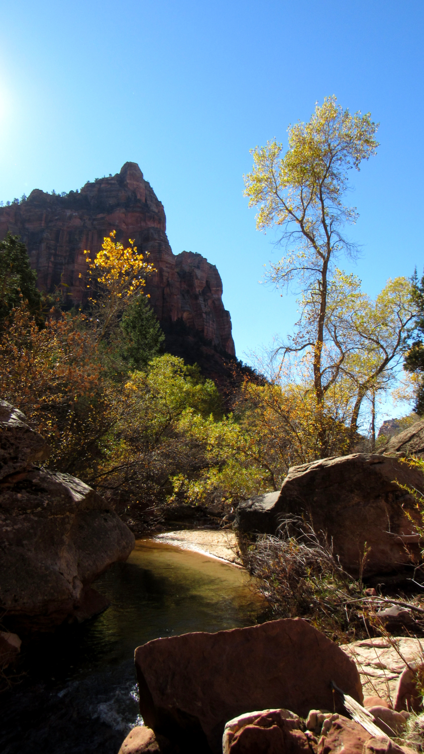
The route to the Subway begins from the Left Fork trailhead and heads gently downhill through a dense woodland of pinyons and junipers. Sculpted sandstone bluffs tower overhead as you proceed toward the rim of Left Fork’s canyon. Once on the rim of the canyon, the now sparsely maintained trail drops a quick 400 feet on steep, rocky terrain down to the creek bed. File the knowledge that you’ll have to climb back up this monster in the back of your mind. You don’t need to think of that now.

The point where this trail reaches the creekbed also represents the most serious navigational challenge on the route. After hours in the canyon, tired and footsore hikers can sometimes miss this junction on the return journey and continue down canyon, adding hours of wandering to try to find the way out. Some hikers tie a bandana to a trail sign as a marker, but without a formal path it is very easy to miss the sign itself. When you get down to the bottom, take some time to commit the terrain to memory. Or, if you are using a GPS device, maintain close attention on the way back to make sure you don’t miss the exit. This is probably the only time you’ll need to use a GPS track here, but it could be the difference between you ending the hike happy or pissed.

For the next 3.75 miles, you will be following the creekbed up-canyon. There are no turns or major navigational challenges to consider. Instead, your immediate concerns will consist of small-scale route-finding and maintaining your footing wherever the terrain gets tough and requires a bit of scrambling. There are countless creek crossings, and occasionally there is little or no trail to follow. When there is a trail it is relatively easy to walk, but it never stays that way for long. All of this off-trail route-finding adds tremendously to the fun of the hike. While everybody comes to see the Subway, the actual journey there is perhaps the most enjoyable aspect for reasons to be revealed shortly.

Several highlights emerge along the way. At 2.3 miles on the left side of the creek, a tilted block of sandstone with an unusual layer of ash-like rock reveals numerous well-preserved dinosaur tracks. Put your hand up to the tracks to see how you compare.

At around 3.1 miles, a small terraced waterfall teases the more famous and infinitely photographed staircase waterfall just before the actual Subway. This waterfall is a sign that you are getting nearer to the Subway itself, but do not mistake it for the actual staircase falls at 3.6 miles.

You will not fail to notice the staircase falls when you reach them. Not only are they an exceptional and unusual example of gravity compelling water over a number of terraced sandstone ledges, they are also incredibly beautiful. Such beauty inevitably attracts a lot of photographers, who will set up shop with their tripods to try to replicate one of the thousands of other photographs of this very spot. This is a great place to stop and enjoy lunch since the Subway itself is too cold and wet for a picnic. When you’ve considered the falls to your heart’s content, walk straight up the falls to the next destination; don’t even both to try to go around, but make sure you’re careful. Black algae can make some spots slippery.

Beyond the staircase falls, you reach another waterfall that is less remarkable but a bit taller. Circumvent that on the right to reach the base of an enormous alcove carved into a cliff. Black streaks of water nourish algae and other micro-organisms, lending a painted look to the alcove. Continue along the creek while taking care not to climb up hillsides where the Park Service has placed signs trying to discourage further erosion.

Past the alcove, the canyon takes a hard bend to the right and enters a gorgeous steep, narrow section that leads directly up to the Subway. Continue along the creek toward the tube that has been gouged into the slot canyon by countless flash floods. The Subway itself is quite short, but opportunities for photography are seemingly infinite. In fact, you can forget about having the Subway to yourself as half a dozen photographers may be waiting at the iconic spot trying to re-capture the iconic photo while you try to muscle your way in to get your own photograph.

This is the end of the line unless you fancy wading through waist-deep water before rappelling up to 20-foot Keyhole Falls. If you aren’t equipped for such a maneuver, don’t even try it. You risk falling and hypothermia without the proper equipment/clothing. Once you’ve enjoyed the scene, retrace your steps back to the climb-out spot to return to your car.

One last note on this hike. I know I risk sounding like a cranky old man about this, but there was an element of disappointment on this hike that I am still trying to process. I have wanted to hike this route for the better part of 15 years since I first became aware that people can wander around in the middle of beautiful places with no agenda other than seeing cool stuff. When I finally did reach the Subway, I met over a dozen people, many with cameras and tripods and some of whom were making all kinds of noise. In a place this unique and beautiful, it’s a little. . . okay, a lot frustrating to have come all this way only to have to patiently wait your turn to take a picture.

I get that this place belongs to everybody and that each visitor has a right to enjoy it (so long as it’s responsibly). However, the destination was a bit of a let down all the same, and I did not linger at the Subway. The journey itself was what made this hike so amazing. All of the rock hopping, fall color, tiny waterfalls, soaring canyon walls, bird song, and variations on the beauty of water in the desert make this an indispensable experience. By all means, get your trophy photos of the Subway, the staircase falls, and the crack, but remember that the best part is what lies between.
Tags: Archangel Falls, Bottom Up, Left Fork, North Creek, subway, zion