This incredibly challenging summit ascent takes you from the desert floor to the snow line and wastes little time in doing so. While the hike forces you to commit caloric genocide, the transcendent views you’ll obtain from the top compensate for every grueling step, every patch of difficult vegetation, and some pretty challenging scrambling up and over large rock outcrops.

Borrego Valley from the upper reaches of San Ysidro Mountain
If you took a moment to peruse the stats for this hike before reading the trip report, your eyes might have bugged out slightly at what you read. If you didn’t look at the hike stats, go back and take a look. Yes. This hike gains 4,500′ in the space of 8 miles. Actually, 2 of those miles are pretty much flat, so really, you gain all of that elevation in 3 miles. Moreover, a lot of the gain comes during a steep stretch before the summit where the rate of climbing is a lot closer to 3,000′ per mile.

So, why? Why am I looking back on this hike with powerful nostalgia and wishing that you will get the same wild hair I got when considering San Ysidro’s east summit? Why am I recommending that you take a hike this difficult? If you’re the sort of hiker who is familiar with desert travel, and if you love a good challenge, and if you want to obtain a magnificent, almost aerial view of Borrego Valley that extends west to Mt. San Jacinto and east toward Arizona, then you’re not going to do much better than this.

Sunrise over Borrego Valley

Cairn beyond Panorama Overlook
All of the usual caveats for desert peak-bagging apply here: you should be in excellent physical condition with a good amount of experience in navigating, handling desert conditions, and dealing with the psychological challenges that come with a hike this hard. You should also be prepared with at least a gallon of water, sturdy footwear, sun protection, a reliable means of navigating, first aid kits (the brush gets pretty aggressive in a few spots), and you should leave a detailed itinerary and plan of return with a loved one. This is not a nature walk by any stretch.

Toro Peak
The elevation spread on this hike ensures that you will that traverses a wide range of vegetation types from cactus scrub to pinyon-juniper woodland. The views are monumental and rival those found on the higher peaks of the nearby Santa Rosa Mountains. The experience of covering all of that ground is at once humbling and exhilarating, and the rewards of conquering the mountain correspond to that dichotomy. You will at the same time brag about the accomplishment and marvel at the fact that you could do it at all. That is one of the great wonders of desert peak-bagging, and this peak epitomizes the experience about as well as any other mountain in Anza-Borrego.

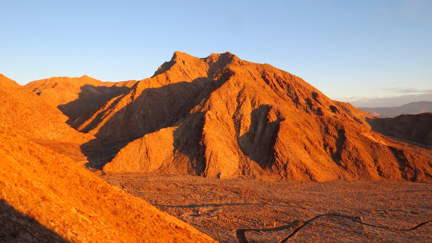
The most rugged, steepest, and challenging part of the ascent
Navigation is a relatively simple affair. After you walk north on the paved trail from the Visitor’s Center, cut due west just before the campground, and follow the well-worn trail to the Panorama Overlook. You’ll continue past the overlook on a trail that gets progressively sketchy. Beyond the overlook, that trail essentially evaporates, and from now on your feet will land wherever the cacti are not.

Borrego Palm Canyon Campground with Coyote Mountain and the Santa Rosa Mountains in the background
The first two miles of the ascent are relatively reasonable with a 1,000′-1,500′ per mile grade through scattered cacti and shrubs. Thickets of agave make things a bit more interesting around 2500-3000′ feet of elevation, and large boulders soon enter the mix of navigational obstacles.

Just follow the ridge
Right around 3500′ of elevation, the brush gets denser, the boulders get bigger, and the pitch gets much, much steeper. At this point, the ascent is more of a painstaking rock-hop trying to find the barest hint of a path through formidable vegetation and rocks. Focus and diligence are your allies here. While this may sound like a chore, the concentration required for something so simple as moving through 100 yards of obstacles is actually a wonderful psychological experience. Compare and contrast that to whatever onerous and mundane tasks you might have to force yourself to do throughout the day, and suddenly picking your way through truck-sized boulders sounds like a grand old time.

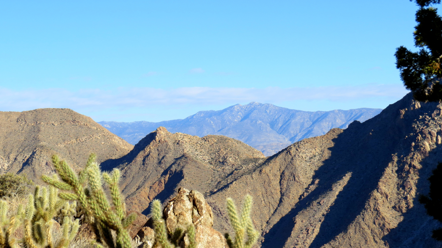
You’ll no doubt notice the view getting more and more aerial the higher you climb, and often these “spoilers” can diminish the final reveal when you reach the summit. However, that letdown didn’t happen for me on San Ysidro. Not only did views north toward Toro Peak and Mt. San Jacinto as well as closer afoot into the cavernous maw of Borrego Palm Canyon add a splash of revelation to the view, but by the time you’re standing over the desert, 4,500′ up but only a few horizontal miles away from Borrego Springs, the shock of just how high you climbed in so short a distance will be something to wrap your brain around.

Christmas Circle
From here, the town is tiny. The roads are abstract ribbons of black threading through a spread of grids, splashes of green, and the duskier squares of citrus groves. Much of the Salton Sea is visible. The vast, bowl-shaped eastern spurs of the Peninsular Ranges spread around the glaring expanse of the Borrego Badlands like massive granitic arms reaching to scoop up the sweepings of ancient seas.

Mt. San Jacinto
To the west, the San Ysidro Ridge extends to the range’s second highest point at Ysidro benchmark. It’s possible to follow this ridge to Ranchita, but the heavy vegetation along the way make that hike a real pants-shredder. Determined backpackers willing to schlep gallons of water to the top can find flat spaces for camping below the summit. Keep in mind that backpacking will cut your already tortoise-like pace in half. Backpackers will need the better part of the day just to get to the top.

Descending
Getting back down is simple navigationally, but nearly as difficult as the climb up. Loose stones, soft sands, and vegetation present the same obstacles in different ways. Slowly, painstakingly, and eventually, you’ll reach the desert floor and finish with an easy walk back to the Visitor’s Center.
Tags: Anza-Borrego Desert Visitor Center, Borrego Valley, Indian Head, Panorama Overlook, San Diego County, San Ysidro Mountain