
The trek to Ramona Falls is one of the most popular and well-traveled hikes in Oregon, and for good reason. This relatively moderate 7-ish mile loop offers up dense forest cover, the Wild and Scenic Sandy River, occasional views of nearby Mount Hood, and — of course — the truly spellbinding 120-foot tall cascades of Ramona Falls.
The hike begins at the Ramona Falls Trailhead — a wide dirt parking area at the end of a r0ugh but passable road (definitely take your time on the last mile or so of that drive, as there are some very deep potholes). There is a port-o-potty and a solar powered permit machine just in case you forgot yours at home. This is a popular trail and it will fill up fast, especially on weekends, so try to get there early.
When you’re all sunscreened up, head onto the Sandy River Trail No. 770 toward Ramona Falls.

Very quickly, the trail dives into a dense forest of Douglas fir and lodgepole pine. If it’s a bright summer day, the shade will be welcome. You won’t have much in the way of vistas here, but you will likely be able to hear the roaring Sandy River just to your north through the tree cover.
You will encounter a bright red STOP sign on the trail at the entry to the Mount Hood Wilderness. Here, you can self-issue a Wilderness Permit, which you will need to carry with you even if you are just doing a day hike here. Fill out your paperwork and continue on the trail.

The Sandy River from the trail
If you’ve been reading anything about this trail, you know there is a river crossing in your near future. Not too far from the trailhead, you will encounter a plaque in memory of 27-year old Sarah Bishop, who was swept away by the Sandy River near the end of her 42-mile backpacking trip on the Timberline Trail in 2004. A PDF of these safety tips for crossing glacial rivers can also be found on the Forest Service website, if you wanted to do some practice beforehand. Some good rules of thumb are to check the weather for a few days before you hike out here, look for a safe crossing, and don’t be afraid to turn around if the water is too high.
The river crossing occurs at around 1.25 miles, give or take. This is not really a maintained crossing, but usually there is a group of logs and rocks that makes sense as the easiest route. If you’re going in the summer, the water level is likely to be on the low side and a clear route already established. If not, please cross carefully and again — don’t hesitate to turn around if the water is too rough.

The river crossing at time of writing
Once you make it across the Sandy River, the trail rises up the eroded shoreline and heads to the north before turning east, vaguely following the path of the river. This section of the trail is a little dusty, especially in the late summer, but you do still get a decent amount of tree cover. Be on the lookout for rhododendron on this stretch, too!

Just before the 1.6 mile mark, the trail meets up with the Pacific Crest Trail. Stay straight to continue hiking east toward Mount Hood.
Overall, this route does not have a ton of elevation gain, but this is the section where you are likely to notice it most. It’s fairly steady but the trail really doesn’t give you any downhill breaks on the way up. Thankfully, you will occasionally get some nice views of Mount Hood in the distance (behind trees, naturally), which helps break up the slog.

If, for some reason, you do not notice the elevation gain in your legs, the trail does open up to give you some glimpses of the Sandy River’s flood channel, which you are now quite a ways above!

It’s no mountain peak, but still — that’s nothing to sneeze at!
Just before the 3.1 mile mark, the Timberline Trail 600 departs from the PCT. Hop onto the Timberline heading toward Ramona Falls, which you’ll reach in just about a half mile.
I honestly don’t know if I’ve ever had an approach to a waterfall like the one to Ramona. You’re walking through a dense, shaded, cool forest and you can hear a cascade somewhere, but you can’t exactly see much. The waterfall sounds different, too — not a roar or a rush — it’s softer, but still enticing. As you approach, you will catch glimpses of something through the trees.
And then, just past a small horse camp, you’ll come right upon Ramona Falls.
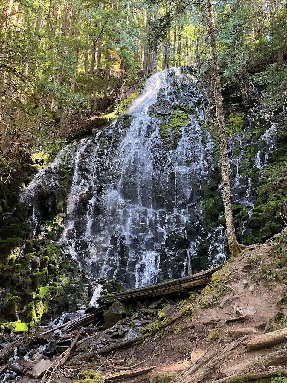
It is, in all honesty, one of the more stunning waterfalls I’ve had the pleasure of seeing.
There were just a few other people here when I hiked, but everyone was just snacking or sipping water, staring at this waterfall in reverent silence. I found a nice mossy tree to lean against, enjoying the white noise as I ate my lunch. Two older women nearby had the truly genius idea to bring their camp chairs in, and they had them set up facing Ramona Falls like it was a TV at a sports bar. And with views like this, how could you blame them?
So when you’re budgeting time for this trail, make sure you leave a little extra on there just to sit around and soak all this in, because it’s absolutely worth it.
Of course, the standard safety stuff is relevant here, too — you’ll see lots of signs around about not climbing up the waterfall or hopping onto use trails that look like they head to the top. All you’re doing is putting yourself at risk and increasing the erosion nearby.
Take your time, and when you’re done, cross the wooden bridge at the base of the falls to continue on the loop.

Just after the bridge, keep left to depart the Timberline Trail and head back toward the trailhead.
This section of trail might be the prettiest hiking on the entire route. It’s a gentle downhill through beautifully shaded forest. A babbling stream follows you downward, providing soft white noise, and to your right a prominent rock wall provides some extra geologic interest.


Hard to argue with scenes like this
It’s about 1.8 miles to a junction with the PCT, which you’ll take back toward the Sandy River crossing and the trailhead again, closing the loop on this excellent day with Ramona Falls.
Tags: Mount Hood Wilderness, oregon, Ramona Falls


