West of the town of Independence, the scrub-covered Owens Valley swells toward the imposing escarpment of the eastern Sierra Nevada Mountains culminating in the spectacular alpine habitats of the Sierra Crest. This hiker’s playground features some of the most popular and highly visited montane destinations in Southern California, including Mt. Whitney, the Cottonwood Lakes, and Onion Valley.

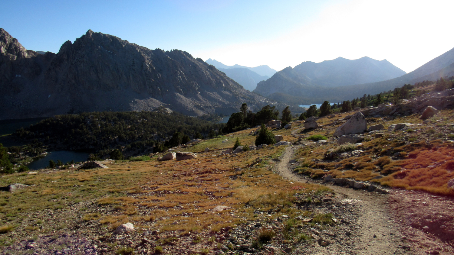
Looking east into Onion Valley and the Owens Valley beyond
The third destination in this trio, Onion Valley, is a heavily used portal into the eastern Kings Canyon high country by way of Kearsarge Pass. Countless John Muir Trail (JMT) and Pacific Crest Trail (PCT) through-hikers rely on the pass as a convenient resupply point on their long journeys through the Sierra. For the less ambitious backpacker, Onion Valley also provides access to the lake-studded, subalpine Kearsarge Basin by way of the winding Kearsarge Pass Trail.

Charlotte Lake at dusk
While most Sierran excursions tend to involve long, multi-day trips deep into the wilderness, a trip into Kearsarge Basin provides a middle ground for hikers who are either new to backpacking or simply wish to explore a beautiful place in a leisurely, circuitous fashion. The numerous lakes within the basin ought to provide enough casual exploration over the span of 3, possibly even 4 moderate days of backpacking.

The Third of the Kearsarge Lakes
In order to camp within the basin, you will need to obtain a wilderness permit.This permit applies across Inyo National Forest, Kings Canyon National Park, and even Sequoia National Park. Inyo National Forest allows hikers to reserve up to 36 permits per day, with another 24 held in reserve for walk-ups. An additional set of restrictions associated with wilderness permits in Inyo National Forest can be reviewed here:
High demand for Kearsarge Pass permits notwithstanding, the reservation process is quite simple. First, visit Recreation.gov’s Inyo National Forest Wilderness Permits Page. Next, select your permit type for a specific trail and for the date range you’re targeting. Finally, select your group size, and click “Search.” This will bring up a range of dates where permits are available. I highly recommend planning your trip early; while I drafted this text (3/27/2017), nearly all permits within the quota period for August permits had already been reserved. After selecting your start date, simply reserve your permit, pay the fee, and consider your permit reserved. For the final step, pick up your permits at the Eastern Sierra Interagency Visitor Center south of Lone Pine.

Gilbert Lake
With preparations made, packs loaded and permit in hand, make your way from the circular, usually full Onion Valley parking area due west toward the trailhead. Bears are an issue here, so be sure to stow any scented items in the bear lockers just east of the trailhead. Set foot onto the rocky single-track just beyond the interpretive sign marking the start and follow a tributary of Independence Creek – the main watercourse draining Kearsarge Pass – to begin your journey. After a sharp switchback and 0.3 mile of moderate incline, keep left at the signed junction for the Golden Trout Lakes.

Heart Lake
Beyond the first junction, the trail settles into a steady climb along the northwestern wall of Onion Valley before climbing up and over a series of moraines impounding several destination-worthy lakes. Dayhikers and backpackers alike will enjoy stops at Little Pothole Lake (1.4 miles), Gilbert Lake (2.1 miles), and Flower Lake via a short spur trail (2.4 miles). Both Gilbert and Flower Lake have a handful of campsites apiece for those getting a late start or looking to take their first day slowly.

Big Pothole Lake
From Flower Lake, the trail climbs away from the next lake in the series (Heart Lake) before approaching treeline via a switchbacking climb along a rocky, foxtail pine-dotted slope. After gaining the top of that slope, the terrain flattens out through a dwarf forest of whitebark pines before making the final zig-zagging climb up to Kearsarge Pass. The deep depression just south of the trail holds a deep, almost startlingly sapphire lake (Big Pothole Lake) with no obvious inflow source.

The View East from Kearsarge Pass
The trail soon tops out at 11,800’ Kearsarge Pass, which also represents the boundary between Kings Canyon National Park and Inyo National Forest. This is the turnaround point for dayhikers given that the climb back up from the basin is a significant endeavor.

A Whole Lotta Kearsarge: the Pinnacles and Lakes from below the Pass
A bit of history before we go any further: the name Kearsarge originates from a bit of West Coast spillover during the Civil War. Pioneering miners who founded the town of Lone Pine held Confederate sympathies, and following the ravages that the C.S.S. Alabama inflicted on Union shipping, prospectors named the nearby Alabama Hills in honor of the Confederate Navy’s exploits. A few years later, the U.S.S. Kearsarge sank the Alabama during the Battle of Cherbourg, and the Union-sympathizing prospectors scouting near Onion Valley named Kearsarge Pass to honor the Union victory, as well as to throw some shade at Confederates in Lone Pine.

First Kearsarge Lake
After stepping into Kings Canyon National Park, descend along the west face of Kearsarge Pass until you reach a Y-junction 5 miles from the start. The two branches of the trail – and upper/north branch and a lower/south branch – run east-to-west through Kearsarge Basin before connecting with the PCT just north of Lower Vidette Meadow. Keep left here to follow the lower of the two parallel trails (the right, upper branch will be your return route). After another .5 mile, you will reach a second junction with a spur trail leading away on the right toward the Kearsarge Lakes.

Third Kearsarge Lake
This scenic trio of lakes lies nestled against the base of the Kearsarge Pinnacles. You will find abundant campsites along the first and second lakes. Although there is a bear box on the north end of the first lake, the park currently (as of 2017) leaves it locked. You will need to bring your own means of food storage in order to protect your food. A second cluster of campsites lies on the west side of the second lake along an informal path. This informal path continues south to the third and largest of the trio. The third Kearsarge Lake is the most beautiful, particularly on a calm morning when the lake’s placid surface reflects a mirror image of the Kearsarge Pinnacles.

Bullfrog Lake
With an established base camp at Kearsarge Lakes on your first night, you can either relax along the banks of the lakes, or you can continue hiking west for a visit to Bullfrog Lake. The park forbids camping near Bullfrog Lake, but since it is arguably the most scenic of all of the lakes in the basin, I recommend you spend as much time along its banks as possible.

Pond below Bullfrog Lake
For your second day/night, you have a couple of options. Per park restrictions, you can spend up to two nights at Kearsarge Lakes. If you opt to keep your base camp here, you can complete the looping hike to and from Charlotte Lake as a dayhike. If you want to camp at a new destination by way of a reasonably short hike, you can return to the junction with the lower Kearsarge Basin trail and turn left toward Bullfrog Lake. Just past Bullfrog Lake, you will skirt the edge of a small, grass-lined pond before reaching a junction with the combined JMT/PCT. Hikers with sufficient energy and inclination can turn left (south) to descend about 1,000’ for an optional visit to Lower Vidette Meadow and Bubbs Creek.

Descending to Charlotte Lake
To reach Charlotte Lake, turn right onto the JMT/PCT, heading north and uphill for 0.4 mile toward a 4-way junction with the Charlotte Lake spur trail, the upper trail returning to Kearsarge Basin (your way out), and the north-south trending JMT/PCT; look for this junction along the edge of a sandy meadow. Turn left at this junction toward Charlotte Lake, and begin a descent first through lodgepole and foxtail pine forest and then along a meadow to reach the eastern banks of Charlotte Lake. The trail continues along the north shore of the lake’s shimmering water to reach a series of campsites, a bear box, and a ranger station.

Charlotte Lake
The return route brings you back to the 4-way junction, where you will continue straight (east) to climb obliquely along a rocky shelf bounding the northern edge of Kearsarge Basin. Your best views south toward the Vidette Peaks and Bubbs Creek Canyon emerge as you continue, and you should also be able to spot Bullfrog Lake and later the Kearsarge Lakes as you approach the pass. Crest the pass and descend back to Onion Valley to finish the route.

View South from the Upper Trail
Tags: Bubbs Creek, Bullfrog Lake, Charlotte Lake, Flower Lake, Gilbert Lake, Heart Lake, Independence, Inyo National Forest, John Muir Trail, John Muir Wilderness, Kearsarge Basin, Kearsarge Lakes, Kearsarge Pass, Kearsarge Pinnacles, king's canyon national park, Onion Valley, Pacific Crest Trail, Pothole Lake, Vidette Meadow