Home to an extensive and well-preserved series of cliff dwellings, Walnut Canyon National Monument is an accessible and fascinating stop for travelers in the Flagstaff region.
The Sinagua people arrived in the region around Flagstaff sometime around the year 600 CE, but they didn’t move into Walnut Canyon until 1100, after Sunset Crater was created after a series of nearby volcanic eruptions. Following a period of increased rain, the Sinagua built cliff dwellings here between 1125 and 1250 and then – like many of their cliff-dwelling brethren, they abandoned the complex settlements here and moved on.
The name Sinagua (Spanish for “without water”) is regarded as a testament to the peoples’ ability to live in such an arid and seemingly inhospitable environment, but in reality the Sinagua were ingenious at tapping the natural hidden water supplies of the region. Their dwellings were often centered around seasonal arroyos and natural springs in the limestone cliffs, which acted as a natural reservoir during the drier seasons. The Sinagua were also known as exceptional traders and had trading routes that reached the coast of the Gulf of Mexico and down into Central America.
Although it’s not clear what happened to the Sinagua, most believe they eventually assimilated into the nearby Hopi tribe. The sites here in Walnut Canyon were left mostly abandoned until Spanish explorers stumbled into the area in the late 1500s, but it wasn’t until the railroad’s arrival in the 1880s that the site began to get damaged and raided by souvenir hunters — a story that is sadly repeated at sites all over the West, including nearby Petrified Forest and other native sites like Wupatki and Mesa Verde.
President Woodrow Wilson declared the area a National Monument in 1915 to help protect the region against looters, and today a small network of trails takes visitors along the rim of the canyon and inside the canyon itself, passing very close to several ruins of cliff dwellings.
We should note that all plants, animals, and archeological objects are protected by federal laws. Off-trail hiking is not permitted in the Monument, nor are dogs.
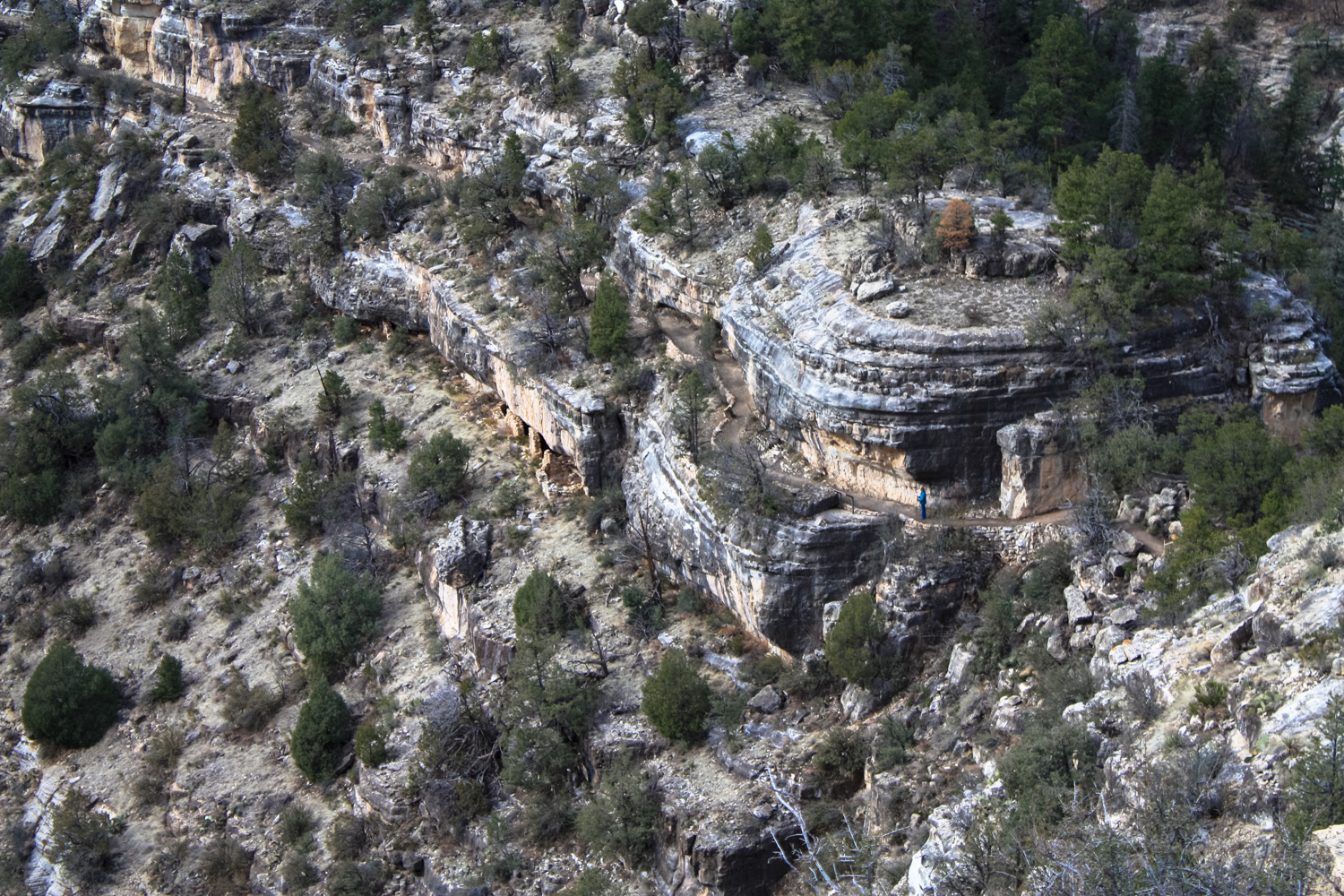
OK – that said, from the parking area, head east along the Rim Trail first. This flat, easy route hugs the rim of Walnut Canyon for about 0.3 mile, meeting two prominent viewpoints along the way that provide excellent views down into the canyon itself. Keen eyes should be able to spot some of the cliff dwelling ruins in the surrounding terrain, while less keen eyes will be able to spot the informative plaques detailing the different plant communities.


Along the rim, you’ll pass through Pinyon / Juniper woodland, marked with their namesake trees, as well as some pockets of the Upper Sonoran Desert, where you’re more likely to see yucca and prickly pears.
The Sinagua people utilized every resource of this seemingly stark environment. Pinyon pines provided food, timber, and adhesive saps. Yucca was an important source of construction fibers as well as food and soap, while the prickly pears’ fruits were well-prized (after the needles were removed, of course). When the Sinagua lived here, ponderosa pine also provided an important source of construction timber.
Backtrack from the second view point and at 0.4 mile, keep right to join a spur trail that heads toward a picnic area as well as the ruins of a pit house and pueblo.
On the rim of the canyon, the Sinagua grew crops in pockets of rich topsoil and built terraces and check dams to conserve rainfall. There are several unexcavated ruins on the rim here (look for the oddly shaped mounds) as well as some reconstructed ruins.

Finish hiking the loop trail and return to the original trailhead at 0.7 mile, then keep right to head toward the Monument Visitor Center and Headquarters. You can pop inside for some helpful interpretive information and maps (and, of course, pick the rangers’ brains a bit), or continue on past the center to the Island Trail.
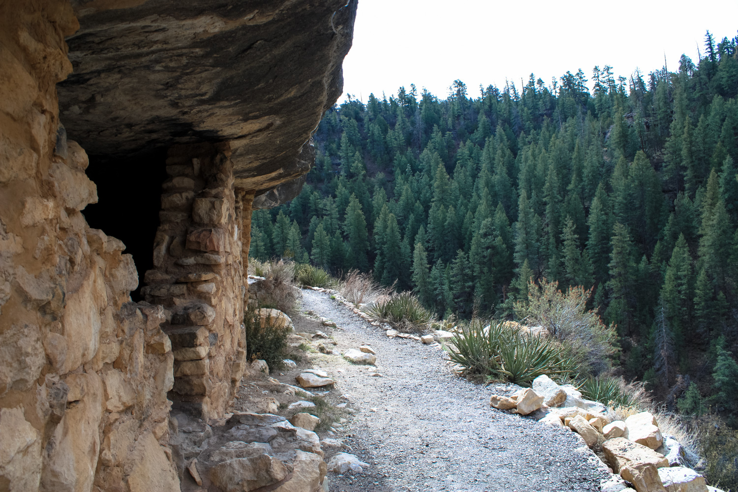
The Island Trail descends down into the canyon and near several ruins of the cliff dwellings, but does not reach the canyon floor itself.
Still, the Island Trail does have some sheer drops along its sides, and you will have to climb back up 185 feet to get to the canyon rim when you’re done, so don’t underestimate this as your run of the mill, easy visitor center trail. Also note that the Island Trail closes one hour before the park closes at 5PM.
Head down the stairs and at the bottom of the trail, you can head in either direction — the trail is a lollipop loop around one section of canyon in a bend above Walnut Creek.

When I visited the Monument, one section of the Island Trail was closed for trail work and renovation, so this route only covers the area on the east side of the Island Trail.

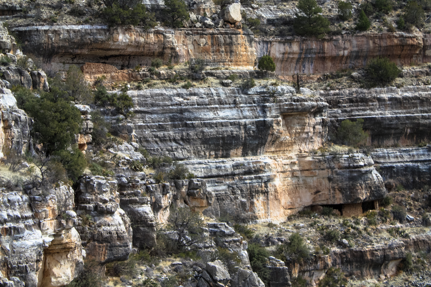
The trail here hugs a level of Walnut Canyon and comes extremely close to some of the cliff dwelling ruins. It’s humbling and fascinating to look at places where people lived hundreds of years ago, where in many cases you can still see the charcoal and soot from their fires.


Many other dwellings are visible from the trail as well, but you’ll have to enjoy them from afar.
The Island Trail, however, does come very close to many of the old dwellings, and gives you an excellent idea of what some of the living conditions may have been like in this canyon. Most of the dwellings are built facing the south and east in order to take advantage of the warming sunlight. A minority of dwellings do face north, which most believe were occupied part-time during the warmer months.

pine forests surround Walnut Canyon
Soak in the amazing scenery, then return back up the stairs the way you came in. And if you didn’t stop at the visitor center before you came down into the canyon, definitely make sure you stop there before you leave!

an encouraging / cautious marker at the bottom of the staircase
Tags: Ancestral Puebloans, Arizona, flagstaff, sinagua people, walnut canyon national monument