This route to one of Borrego Valley’s iconic peaks features a sampling of the best features of Anza-Borrego Desert State Park all rolled into one. The views from the summit of Indianhead Mountain are spectacular, as is the vertigo-inducing ascent. This hike is a must for all lovers of the Anza-Borrego Desert.

Ocotillo at dawn
Anza-Borrego Desert State Park is rich in all of the things that make the desert an incredible place. In this massive 600,000-acre park covering one-fifth of San Diego County, you will find countless rocky peaks, austere canyons, palm oases and desert riparian zones fed by springs and year-round creeks, spectacular views across stark landscapes, and, if you’re lucky, encounters with the park’s namesake denizen – the Peninsular bighorn sheep, known in Spanish as Borrego.

Rock Wren
While all of these natural features can be found in abundance within the park, very rarely do they intersect in one hike as they do at Indianhead Mountain. On this challenging ascent of one of Borrego Valley’s signature landmarks, you’ll encounter all aforementioned natural features in their most spectacular expressions.

Indianhead Mountain
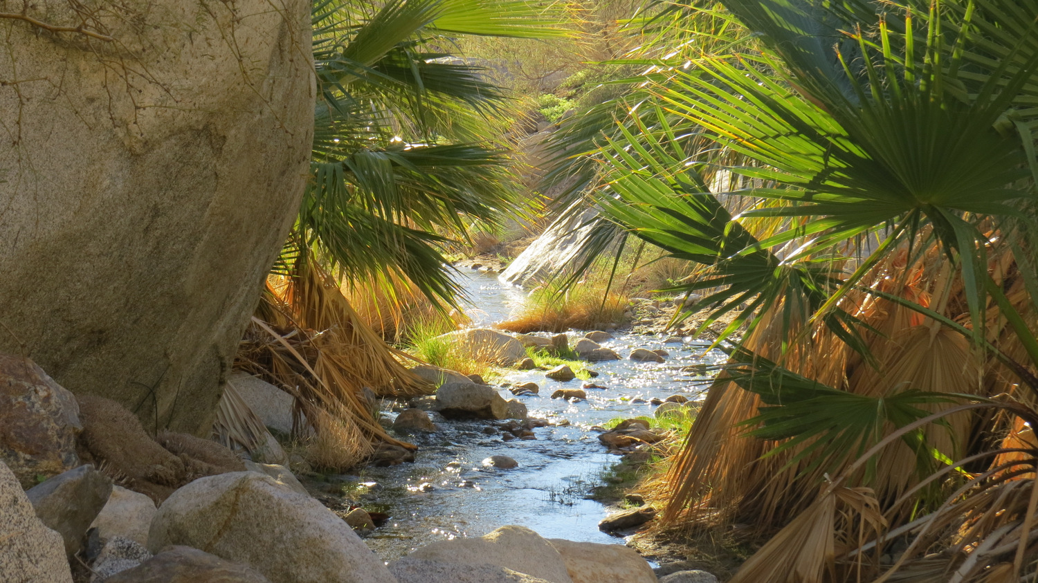
This route follows the course of Borrego Palm Canyon, which features a year-round creek nurturing groves of California fan palms as well as the resident herd of bighorn sheep. From a point deep within the canyon, hikers can follow a pair of steep, rocky ridges up to the summit of Indianhead Mountain – commonly referred to simply as Indianhead – where an impressive panorama of Borrego Valley, bounded by the Santa Rosa Mountains, Salton Sea, Pinyon Mountains, and San Ysidro Mountains, awaits.

One of many small cascades within Borrego Palm Canyon
It should be noted from the outset that is a very challenging route. Inexperienced hikers unaccustomed to desert travel should not attempt this hike unless accompanied by somebody familiar with the route. This route contains navigational challenges, including long trail-less passages up Borrego Palm Canyon and the steep ridge leading to the summit. Numerous plants with sharp spines abound, and there are several sections where footing is unstable. There are several spots on the ridge up to the summit and on the summit ridge itself that may require some mild scrambling. Additionally, some sections of the route are very steep. Finally, excessive heat and sun exposure pose risks to all hikers. Be sure to bring adequate hydration (at least a gallon – more if it’s hot) and be sure to use every manner of sun protection available, including light-colored, loose-fitting clothing, wide-brimmed hats, and sunscreen.

Pioneer palms along the creek
Commence travel by joining the Palm Canyon Nature Trail as it travels east into the depths of Borrego Palm Canyon. This trail is one of Anza-Borrego’s signature hiking destinations, and you are likely to encounter a number of other hikers through the first 1.5 miles. The main attractions here are the bighorns, which are frequently sighted within the canyon. The canyon also plays host to an impressive number of bird species, making it a popular destination for birders. During spring, wildflowers displays are present and can be a magnet for flower enthusiasts. The canyon’s scenic beauty leading up to the first grove of California fan palms are destination enough, drawing hikers even during the hot summer months.

California Fan Palms at First Grove
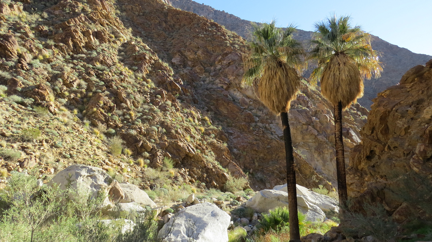
Follow the well-defined trail to First Grove, where you’ll encounter the remains of a once-massive palm grove that was thoroughly decimated by a 2004 monsoonal storm. During this storm, a wall of water careened down the narrow canyon, uprooting palms and dragging them down-canyon for miles. The first 1.5 miles of this hike are littered with dead palms, but the area around First Grove displays robust growth from pioneering palms and other riparian species such as willows, sycamores, and cottonwoods.

Beyond First Grove
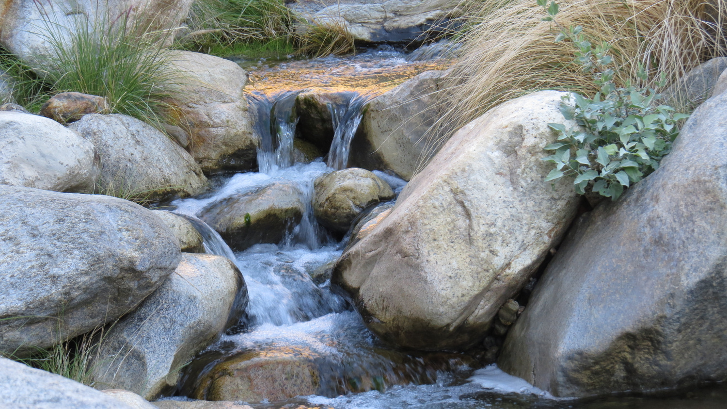
Pause to enjoy the palm grove, as well as a small waterfall that is usually flowing during winter and spring. On the right, you’ll find a faint path leading up and over an outcrop to an obscure viewpoint overlooking the grove. From here, you can commence an off-trail passage through the middle reaches of Palm Canyon. There may be faint traces of trail passing through recovering creek-side vegetation and invasive patches of fountain grass. You can follow the trail, such as it is, hopping across the creek at times, or you can simply stick with the course of the canyon overcoming numerous small obstacles like boulders, small waterfalls, or overgrown patches of vegetation. In grassy spots, keep your eyes peeled for rattlesnakes, especially during early spring.

Waterfall near the Anvil of the Sun
At 1.8 miles, you round a bend and reach a decimated palm grove. Around this point, different bands of tan- and orange-tinted metamorphic rocks like gneiss and schist extrude out of the omnipresent granite. Several waterfalls cascade down some of these outcrops before the third grove of palms, presenting both a pleasing sight and a possibly challenging scrambling obstacle. In a few spots such as Third Grove, the trail climbs up and over the creek; be sure to stay above the creek in these spots to avoid damaging the recovering vegetation. Possible campsites occur in several spots on sandy banks within the canyon.

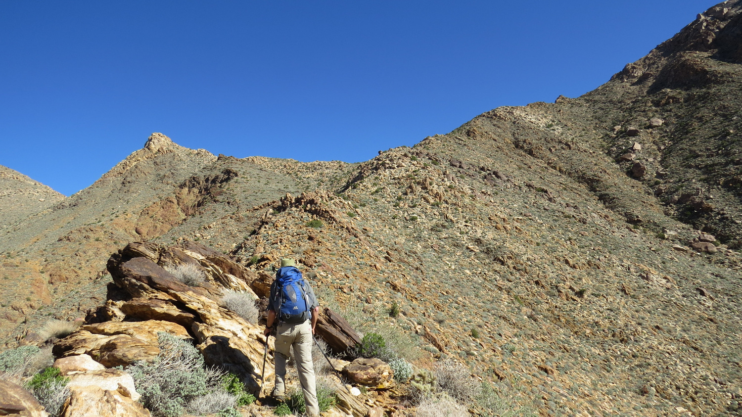
Ascending the ridge
At around 2.7 miles, you reach a point where a tributary canyon joins from the north. The real ascent of Indianhead begins on a steep ridge dividing that tributary from Palm Canyon. Begin climbing the ridge, aiming for a prominent white boulder that also marks a spot where a faint path begins to faithfully follow the ridge. Bear in mind that this is a path in the faintest and vaguest sense of the word. At many points, the path may simply be the most reasonable route over boulders and through patches of agave and cholla. Be warned that the section between the bottom of the canyon and the summit gains 2,000’ in a little over 1.5 miles. This is some really difficult hiking that will certainly turn back the unprepared and insufficiently motivated.

Ascending Indianhead’s ridge
At 3.5 miles, you’ll reach a saddle with a view overlooking Coyote Mountain, the Santa Rosa Mountains, and the lower reaches of Coyote Canyon. At this saddle, turn east to begin climbing Indianhead’s summit ridge. The once-formidable vegetation obscuring possible paths between large boulder piles burned in a recent wildfire, making passage a bit easier for the next few years (dated from 2015). Passage through this section may become more difficult as the vegetation recovers.

Indianhead Mountain
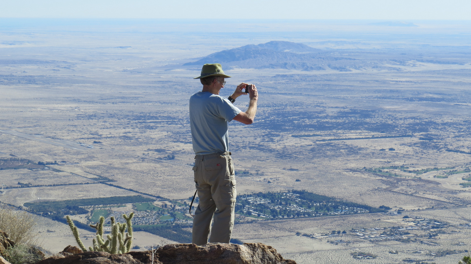
After 0.65 miles and another 700 feet of climbing along the summit ridge, you will arrive at the comfortably flat summit, where all of the effort of the past few hours is rewarded by a stunning panorama over the vast expanse of Borrego Valley. Most prominent are the landmarks bounding the valley, including the Santa Rosa Mountains to the north, the Salton Sea to the east, the Pinyon and Vallecito Mountains to the south, and the upper reaches of the San Ysidro Mountains to the west. Additional landmarks, including Mt. San Jacinto, the Borrego Badlands, and some of the Peninsular Ranges to the south are also visible, but the now-tiny network of roads, houses, golf courses, orchards, and seemingly barren desert of Borrego Springs seem perhaps most remarkable given the perspective from the peak.

The return route retraces the approach, although special caution should be exercised over the descent from the summit and saddle. In many spots, the footing can be a bit unstable, and a wrong step could send you careening downhill into unfriendly cacti and jagged rocks. The jaunt back down-canyon can be a lot of fun, provided you still have some energy left after the climb. Just beyond First Grove, an alternate trail branches off of the main trail providing a meandering return loop for those so inclined.
Tags: Anza-Borrego Desert State Park, bighorn sheep, borrego palm canyon, Borrego Valley, California Fan Palm, Indianhead, Indianhead Mountain, Palm Canyon