While Rancho Sierra Vista and Point Mugu State Park are currently closed due to dangerous conditions from the winter storm, Park Rangers and scientists are inviting the public to participate in a truly unique and groundbreaking program to document the landscape’s recovery after a wildfire.
In May of 2013, the Springs Fire swept through over 24,000 acres in the Santa Monica Mountains. Following the heartbreaking multi-year forest closures of the 2009 Station Fire, many were surprised and delighted when park officials re-opened most of the Springs Fire burn area only a few weeks after the last embers went out.
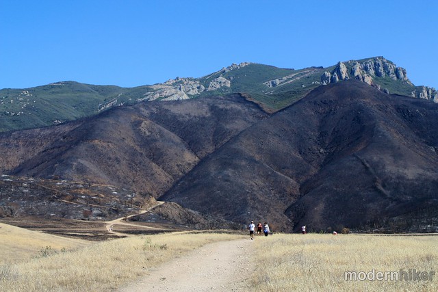
Hikers below Boney Peak shortly after the Springs Fire.
I hiked in Point Mugu State Park shortly after it re-opened and was impressed that parts of the chaparral already seemed to be on the mend – and that the public was given a chance to see a fire recovery in a very tangible way.
Shortly thereafter, a joint project between the National Park Service and California State Parks asked hikers to document their visits to the region at ten different locations. By snapping photos at these places and tagging them on social media, they were able to start building an interactive online time-lapse map of the area’s recovery. Photos can be uploaded via Flickr, Twitter, or Instagram and tagged with individual station numbers, or visitors can email their images directly to the Park Service.
Marti Witter, the fire ecologist for the Santa Monica Mountains National Recreation Area, said the Springs Fire area has been dealt a tough hand for recovery but it can still rebound. “The Springs Fire was unprecedented in the sense that it was so large and burned in the spring and not the fall,” he said. “When you add a record-breaking drought to the mix, we’re talking about an extraordinarily challenging set of conditions for post-fire recovery — hopefully this storm will give the vegetation a boost.”
Because Rancho Sierra Vista and Point Mugu State Park are under temporary closures due to hazardous conditions from the storm, check the closure status at www.nps.gov/samo or by calling 805-370-2301. More information on the project and instructions on how to share your images can be found here (PDF).
Modern Hiker has write-ups for Sycamore Canyon, La Jolla Canyon, and Mugu Peak in the region.
Featured Image: Park Ranger Mary Holmes de Calvaresi shows a young visitor how to place her smartphone onto the photo-monitoring station. Ten camera stations are located within the burn area of the 2013 Springs Fire to track the landscape’s recovery. Courtesy National Park Service.
Tags: National Park Service, Photography, Point Mugu State Park, science, springs fire