While I was back on the East Coast, I had the opportunity to test out the beta for EveryTrail’s new iPhone App (which has since gone live).
For those of you who don’t know, EveryTrail is a free user-built database for GPS-enabled outdoor activities of every kind. Users can upload their GPS tracks and photos to create elegant online trip reports (with automatic photo geotagging!), then post those trips for others to find, recommend, and comment on. It’s a free web site and a great way to see what kinds of activities are in your area, and their new smartphone app truly incorporates the user-friendliness EveryTrail is known for.
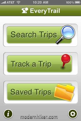
After downloading the app, you’ll be asked to create an EveryTrail account or enter the information for the one you already have. While it’s not necessary to use the app, it does add a lot of functionality, like the ability to save your tracks to the web site to later edit and share online. The startup screen is pretty basic, and gives you an idea of what this app is supposed to be used for:
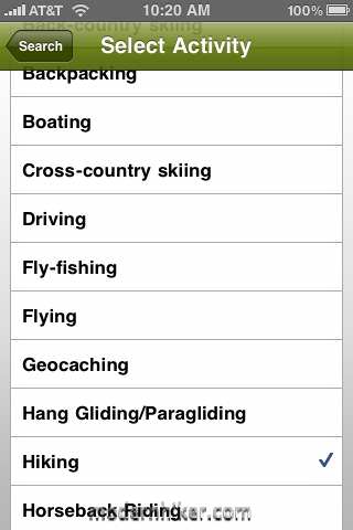
Since I was in an area I hadn’t done much hiking in for a while, I decided to see what was in my neighborhood. You can search near a specific location, use the iPhone’s GPS to find trails within a radius, and even specify what kind of activity you’re looking for — and there are a lot of different options:
Once you’ve set your search terms, you’ll get a list of all the trails other users have uploaded, with the ability to sort by user rating, length, or proximity.
Choosing a trail will bring up all the basics. Depending on who uploaded (and what hardware they were using), you’ll get distance, time, elevation profiles, the GPS track on a Google Map, and pictures. Opening up the trail info will allow you to browse all of these items in detail and – most importantly – offers the option to save all of this information to your phone. This allows you to have access to the map even if you don’t get cell phone reception where you’re hiking. The app will also give you driving directions to the trailhead from your current location, which is a nice touch.
The advantage to doing trail downloads like this is that you don’t have to worry about maps taking up huge chunks of space on your phone, but the downside is you’ll be relying on Google Maps for your trail information – and (as of this writing) only in Street or Satellite modes, not the more topo-looking Terrain Mode.
Overall, though, finding hikes is easy, and downloading the information you need is quick and simple. It’s a very well executed system.
The EveryTrail app also functions as a GPS receiver, allowing you to track your progress, take geotagged photos along the way, and add waypoints. This is all accomplished on a map screen using collapsable menus and easy-to-read icons. EveryTrail recommends you keep the iPhone locked and secure in your pocket while you’re hiking. If you get a phone call, the app will automatically pause your tracking for a moment and resume when your call is done, but you’ll probably want to turn off your phone to conserve battery power anyway.
When you’re done, you can view the same sort of basic trip summary you could see while browsing for new trips before:
When you choose to stop recording your trek, the app will give you the chance to name it, choose an outdoor activity, and upload it to EveryTrail. You can also choose whether or not to make the trip public, or to announce your trip on Twitter and Facebook.
When it’s all done and you get home, you’ll probably want to log on to EveryTrail to write a story for your trip and include tips. The EveryTrail web site itself is really quite impressive – you can embed a version of your trip onto a variety of blogging platforms, send links via email, Twitter, and Facebook, and download your trip in both Google Earth KML and standardized GPX formats – whether you’re using the mobile app or uploading a GPX file from your GPS receiver. Here’s an example of an embedded trip I did a while back, to give you an idea of what you can do:
Bighorn Peak and Ontario Peak
Final Word:
Earlier, I reviewed the AccuTerra app for the iPhone, which is very similar to the EveryTrail app in terms of function. The EveryTrail app does have a few advantages over AccuTerra – it’s free, it takes up much less space on your phone’s hard drive, and it’s designed to search for trails, which AccuTerra is not. After your upload your track to the web site, you can also share it as a fully fledged GPX file – which makes it easier to share with other GPS users.
However, the AccuTerra high-resolution topo maps blow Google Maps out of the water in terms of readability for hiking. Even if EveryTrail incorporates Google Maps’ Terrain Mode into their mobile app (like they have with their web version), the level of detail will never match the large files AccuTerra uses. The AccuTerra maps not only have more detailed contour lines and shading, but they also mark trails, campsites, ranger stations, and other landmarks important to hikers. If you know the trail or the area you’re hiking in, you’ll probably be all right with the EveryTrail maps, but if you want to do any exploring at all, you’ll want AccuTerra’s maps on your phone.
EveryTrail’s true strength (and weakness) lies with its user base. Searching for trail write-ups is easy, but since there’s no editorial staff weeding out the submissions, you never know what level of detail you’re going to get when you look for a trail. I have seen some REALLY incredible write-ups on EveryTrail, with levels of detail that would rival the best professional guidebooks. I have also seen some with bad information, poor spelling, and confusing and potentially dangerous paths. You still have to take users’ words with a grain of salt (and definitely do your own research and have your own hard copy map, too).
Overall, EveryTrail did a very good job on this version of their mobile app. While I’d still like to see terrain mode in the map view and visualizations of elevation profiles, its strengths far outweigh its weaknesses. It’s small, free, and simple, and the accompanying web app is a robust GPS program that everyone should try out.
Download EveryTrail for iPhone, or download for Android, Windows Mobile, and Blackberry here.
Tags: everytrail, GPS, iphone, iphone app, mobile, Review


