It’s that time of year again. The time when trails get wet, slick, and maybe icy. While safety on our adventures should be a concern year-round for all hikers, it’s especially important during the winter months when conditions are often unpredictable. While hiking trails present certain risks at all times, it’s also during the winter months that I’m reminded of how VITALLY important safety is. Here in the pacific northwest, it’s not uncommon to see stories of lost, stranded hikers, who don’t show up at home after a day on the Columbia River Gorge, oftentimes requiring multi-day searches. While many of these stories have a happy ending, some don’t.
Fortunately, as proactive adventurers who take safety and peace of mind seriously, we can add another tool to the ten essentials we already carry on all day hikes (right? I hope you carry these): The Cairn app for iPhone.
Before we get into the review, a disclaimer: We can’t guarantee that any electronic device is fool-proof (after all, batteries die and phones break), and they are never a replacement for hard copy maps and navigation skills. The Cairn app is however a great addition to the skills you already have.
What does it do? In short, Cairn has two major functions: First, it allows users to let friends and family know where they’re going, where they’re starting from, and when they expect to be back. Second, using crowdsourced data, it provides a map of where certain cell carriers might get service along the trail. All useful things! As a hiker who often sets out on afternoon solo adventures, I’ve found the Cairn app to be an easy tool to use on regular basis, even during the warmer winter months when conditions are safer. In order to show how Cairn works, below, I’ll briefly go through a hypothetical trip to Triple Fall on the Columbia River Gorge.
The sun is out (well, this is Oregon, so maybe it isn’t), it’s a beautiful day, and I decide that it’s the perfect opportunity to go for an afternoon hike to Triple Falls. Either at home or at the trail-head (wherever I get service) I fire up the Cairn app, and am prompted to enter my destination. If I want to change my starting trailhead, I can simply tap the name of the one currently specified, and pick the one I want.
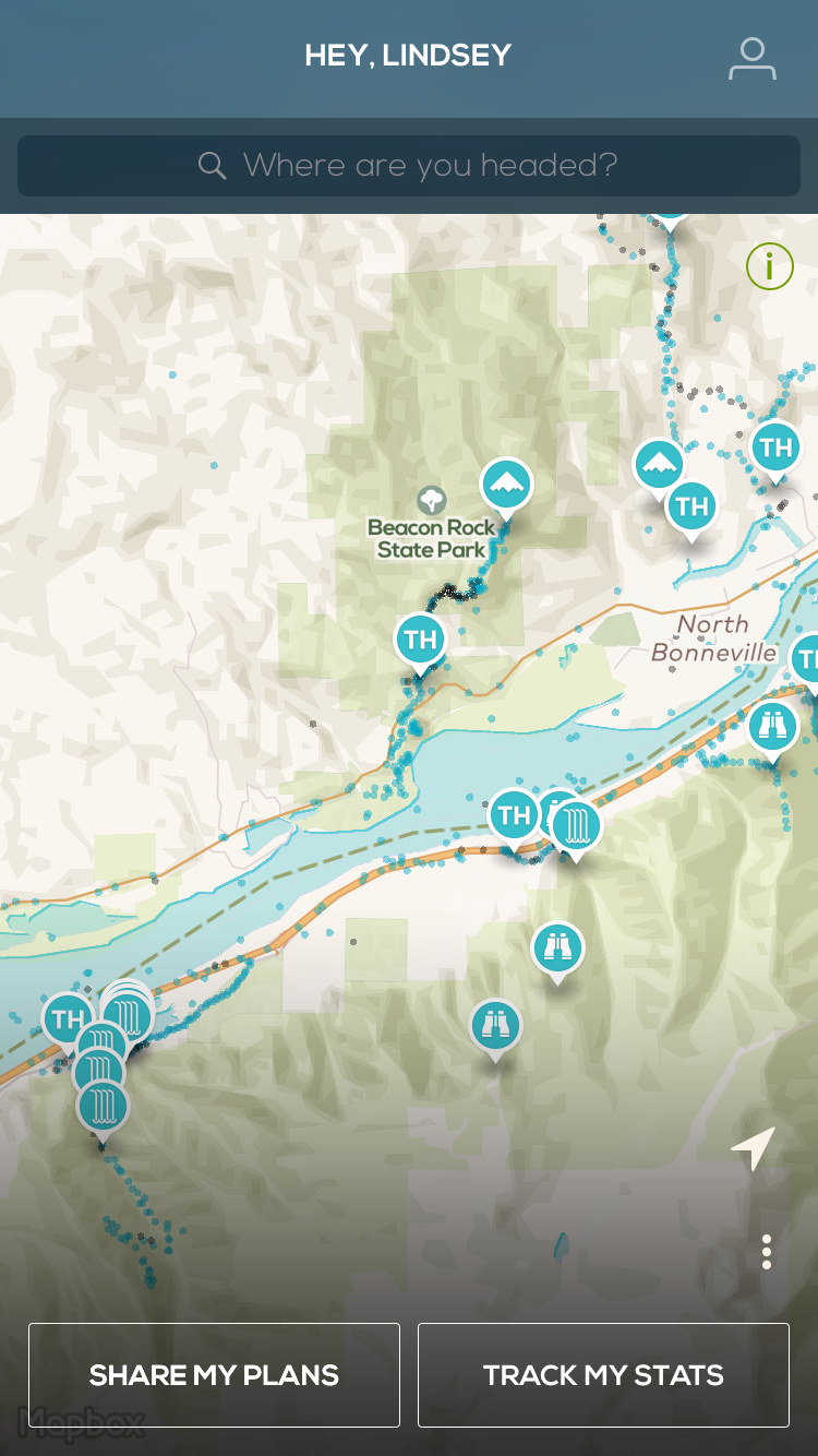

Once I’ve picked my destination and starting point, I can download a portion of the map for offline usage, and proceed to lay out my plans to send to my selected contacts. To download a section of map, simply select the “Map” button, and you’ll be taken to a screen where you select the size you’d like.


Once I’ve filled out all the fields, the app will send your trip plan to your contacts with a interactive map. For my contacts, I usually choose to send messages via text and email, but that’s up to you. During your hike, if you have access to cell service, you can let your contacts know you’re okay, and also get basic trip stats.

Once you finish, click on “End Trip” to let your contacts know you’re back at your car.


At this point, you might be wondering about all those little blue and gray dots. By selecting them, you’re able to see where certain cell carriers get service (blue for service, gray for no service). These are crowdsourced via the app. By using Cairn on a trail, you’re adding to the available data other users will eventually be able to see indicating where cell service can be found.
Finally, while not useful to every hiker, it’s important to note that you’re not limited to selecting pre-identified locations searchable on the map. Say you’ve decided you want to climb a ridge to an unnamed hill because you heard the view is great (and you’re also carrying that paper map too, right?). Just hold your finger at that point and you can drop a pin to indicated your destination. While you won’t get a trail to that spot, you’ll still be able to indicate your starting and ending locations.

Overall, the Cairn app is a powerful tool that easily allows hikers to let other know their adventure plans while also getting an idea of where their phone might work in an a emergency situation. As noted, electronic devices are never a replacement for other maps and safety skills. As a frequent solo hiker, using Cairn has given my family and friends peace of mind. Furthermore, I know that if something happens to me, search and rescue can save valuable time. To top it off, it’s free!
Tags: Backpacking, Cairn, iphone app, maps, nature, outdoor education, outdoor electronics, outdoor safety, outdoors, product review, safety