On Easter, I took a short hike into Bear Canyon. The purpose was two-fold: 1). to get into some of that icy water on a hot day 2). to take a fancy new Garmin Colorado 400t GPS unit onto the trail for a short test.
I clipped my trusty eTrex Legend Cx onto its normal position on my left shoulder, and used a carabiner included with the Colorado packaging to attach the newer unit to my right shoulder. I wanted to compare the two units’ receptions and interfaces … and I wanted to go onto the trail knowing I looked like a total dork.

So let’s get the first impressions out of the way:
Aesthetics:
Wow, this thing is pretty. Guaranteed, that will be the first thing you say when you take your receiver out of its packaging. The screen takes up an overwhelming majority of real-estate on the unit’s face. There are two “soft shoulder” buttons above the left and right corners of the screen, with the large “Rock ‘n’ Roller” front and center.
The top of the unit has a small power key and a rubber flap covering the USB input jack and an external GPS antenna port. The back of the unit has a small plastic clip that locks it together. When unhinged, the entire back slides off to give you access to the batteries and the SD card slot (the 400t comes with maps already installed in the internal memory).
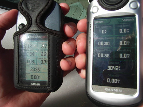
For its sleek design, the unit feels solid and sturdy without being heavy — but the unit did flop around on the carabiner. I’d recommend a clip-case style attachment if you’re going to be clipping this onto a pack. It weighs 5.9 ounces without batteries. It is, overall, slightly larger than the Legend, as you can see in this side-by-side.
You’ll appreciate the fact the designers gave so much of the unit’s face over to the screen. It displays maps, information, and images in (relatively) high resolution (240×400) … but it is, in my opinion, overly glossy. Very rarely have I ever had a problem reading my Legend in direct sunlight. With the Colorado, I found myself constantly tilting or adjusting the backlight.
This can be a problem, even in lower light situations. Here is the Colorado in moderate indoor light on my desk.
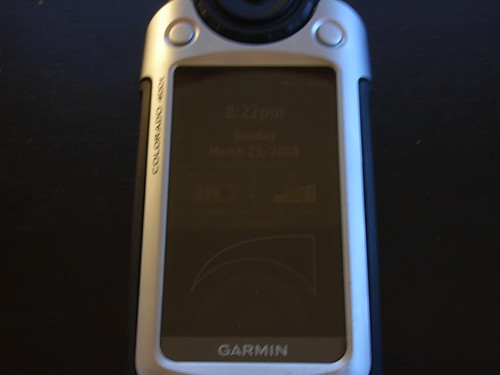
You can read it only if you tilt it toward the light. Otherwise, you’re going to have to crank up the backlight — and really, you’re only going to notice a difference when it’s maxed out.
Up In The Sky – Satellite Reception:
When you first turn on the Colorado, you’ll be met with a splash screen, telling you the unit is loading up its maps. This will probably hang on the screen for a few moments — the Legend started up way faster.
The Legend also found satellites faster than the Colorado — AND it found more of them. It took only 40 seconds for the Legend to lock onto enough satellites to get within 30 feet of accuracy. In fact, after three full minutes, the Colorado had found 6 satellites with an accuracy of +/- 56 feet. That’s decent, but by the same time, the Legend had locked on to 12 satellites with an accuracy of +/- 7 feet.
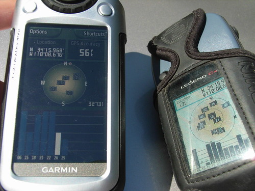
That said, once the Colorado locked onto enough satellites, it seemed to do a better job of sticking to them. I found the Colorado’s readings to be slightly more accurate than the Legend, especially in the more narrow sections of the canyon.
While both units suffered from the occasional bout of “GPS Freakout” — a brief period when the unit loses a satellite or two and thinks it’s far away from where it actually is — the Colorado had much less variation in its measurements. Both units freaked out at the same resting location, and while the Colorado looked like it was just wandering around the area …

… the Legend looks like it did a super-speed leap up a nearby ridge.

As I write this section in my apartment, next to a window, the Colorado is showing me moderate signals from 7 satellites – enough to accurately plot my location and elevation. That’s INDOORS. This thing finds satellites. Just give it a few minutes.
Rock n Roller Frustration:
I’ll be honest. Very rarely do I load a track into my GPS at home to follow on the trail. More often, I use my GPS to see where I’ve gone and to make sure I can find my way back down. While hiking, my interaction with my GPS unit is limited to checking how far I’ve gone, adding and naming waypoints, and measuring distance, speed and elevation gain. So when I took the Colorado out, I wanted to see how it would stack up to those activities.
The menus on the Colorado are not the most intuitive things in the world. To see your track, check your satellite readings, and add waypoints, you’ve got to maneuver your way through a circular menu – and often, through submenus. To switch to the map on my Legend, I hit the X button on the right hand side twice. To input a waypoint, I press down on the thumbstick and then use the same device to input letters on a keypad. It’s fast and easy to do:
To do the same on the Colorado, I press the center of the Rock n Roller, then have to select to edit the waypoint, then have to select to edit the waypoint’s name, THEN have to use a rotating selection of letters and punctuation points — no “shift” key like the Legend. If you like to name waypoints on the trail instead of trying to remember them when you get home, this is going to irritate you after the second or third time.
While in Map Mode, you have to hold the Rock n Roller down in order to scroll over the map, and turn the Roller to zoom in and out. The problem is that every time you hold the Roller down to scroll, you’ll end up turning the Roller a notch or two when you lift your finger off.
Maybe you’d get used to this after a while. But I wasn’t digging it.
Show Me The Visuals:
OK. This is where the Colorado really shines. Once you pump up the backlight, that is.
Maps are BEAUTIFUL on this thing. The pictures are clear and sharp — and even though you’re still only getting 1:100k scale (unless you spring for the extra, limited coverage 1:24k resolution maps), the added bonus of 3-D shading makes a big difference in helping the user visualize his or her surroundings. As on older models, you have the option of orienting the map to always have North at the top, instead of pointing in the direction you’re currently facing.
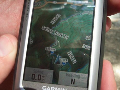
Landmarks, your track, and roads are drawn quickly on zooms, which scale from 500 miles to 20 feet. When scrolling, however, there is a slight delay before new information shows up.
The Colorado also displays some other interesting graphical information. There is a running elevation plot available from the main menu, that shows a profile of your trip so far. You can change the X-axis between physical distance and time spent moving, and it’s a great way to get an idea of what you’ve done so far.
The 3-D Map feature, one of the many bells and whistles buried in submenus, is less than useful, however. While it is neat to look at, it’s got slow draw times and difficult controls. You can get a much better idea of your surroundings from the shading on the 2-D map, and you can get it a lot faster.
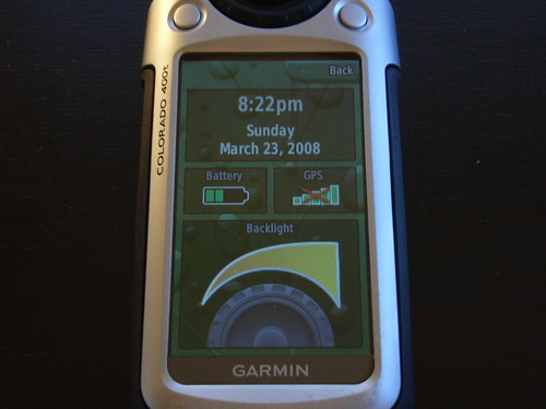
OK, What Else?
Unlike what some commenters have said on this site, the Colorado DOES actually include a trackback feature — so if you want to wander into the woods and still be able to find your way out, you can do so. It’s still got the compass view, overall trip computer view, sun and moon rise and setting estimates, alarm clock, and a mode to give you directions on city streets. Actually, with a dashboard mount, this could be a nice stand-in for a Nuvi — as long as you don’t mind your directions not being narrated to you.
The Colorado can also view images if you insert an SD card. Pictures look good on the screen, but I don’t know when you’d ever use this. I also don’t know when you’d ever use the ability to wirelessly beam information to another Colorado, but it can do that, too.
Geocachers appear to be going nuts for the Colorado’s “Paperless Geocaching” ability, as well. While geocaching seems interesting, I haven’t really done it so I can’t comment. But there is a short geocaching demo “game” included on the Colorado, that will make you walk around to different distances and reward you with clues. Neat, if you’re into that sort of stuff.
Now You’re Almost Out Of Batteries:
The manual says two AA batteries are supposed to provide “up to 16 hours” of power, but I found the Colorado to be a HUGE battery hog. It might have been me poking and prodding with the mapping functions on the trail, or needing the backlight to get good images, but at the end of my 5 hour hike, the Colorado’s fresh batteries gave out completely. While writing this review over a few hours, I also got a message alerting me that the unit no longer had enough power to display the full backlight or create tones.
I’d be interested to hear if anyone else had a similar response with their Colorado’s battery life. My Legend can last for three full days of hiking on the same pair of AA’s. 5 hours of battery life is really unacceptable for a trail-centric GPS receiver.
Final Word:
The Colorado is a beautiful GPS unit that provides excellent reception and truly impressive mapping capabilities. After getting to play with one for a few days, do I still want one? Oh, hell yes.
But am I glad I didn’t rush out and buy one the day it came out? Absolutely.
600 dollars is a very steep price to pay for a handheld GPS — even a state-of-the-art one like the Colorado.
Satellite reception is slow, but very accurate once it gets a hold of them. You can even get reception indoors in some cases!
The maps are gorgeous on this unit. The display is large, sharp, and — in the right lighting — very clear. While the 3-D map feature isn’t very useful, the 2-D maps are bright and informative — and they have 3-D shading, too.
The Rock ‘n’ Roller, as an input device, takes some getting used to. Personally, I prefer the thumbstick on the Legend, but by the end of my time with the Colorado, I noticed my fingers were no longer slipping over the circular control wheel and activating other features. Garmin touts this as a “one-handed control” unit, but really, you’re able to do that on all their handhelds.
The circular control scheme is especially irritating when trying to input waypoint names in the field. Instead of having a shift button (like, say, using one of the two shoulder buttons), you have to scroll through a complete set of lowercase and capital letters, numbers, and symbols to find the one you want.
The way the main menu is setup when you open the unit buries some of the more commonly-used features in submenus, but you can easily edit that menu to your liking.
The battery life, at least from what I’ve experienced, is quite poor. But aside from that, the main deterrent to buying a Colorado is the price. A Garmin GPSMap 60CSx does most of what the Colorado can do at less than half the price. A less fancy but still functional Legend Cx will cost you about a quarter of the Colorado’s sticker.
Those are hard deals to pass up.
Tags: Colorado 400t, Field Test, Garmin Colorado, Garmin eTrex Legend Cx, Garmin GPS Review