Whoa! FANTASTIC news just arrived in the Modern Hiker inbox – the Angeles National Forest has just announced it will be reopening almost all of the areas currently in the Station Fire Burn Zone effective this Saturday, May 24th!
About 46,000 acres of land are now re-opened to hikers, backpackers, and nature lovers of all types. A few areas remain closed for further repair work on trails or for public safety, but now the vast majority of the Angeles is good to go.
I haven’t seen a map of the new Station Fire Burn Area closure zone yet, but as soon as I do I will update the map on my Fire Closures page.
The areas and trails that remain closed are as follows:
- Lower Gabrielino Trail below Bear Canyon
- Barley Flats Trail
- Ken Burton Trail
- Colby Trail
- Millard Waterfall User Trail
- Santa Clara Divide Road (FS3N17)
- Messenger Flats Campground
- Lightning Point Campground
- Big Buck Campground
A tremendous thank you to all of the Forest Service employees and volunteers who have been working so hard to restore this area … and remember, if you want to see those other areas and trails open up sooner rather than later, get out there and lend a hand!
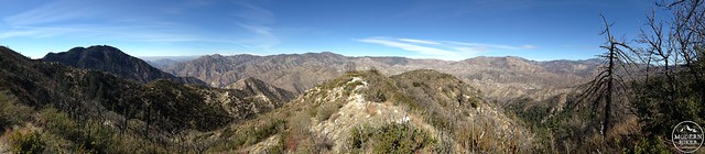
The Station Fire Burn Area as seen from the Strawberry Peak Trail
Tags: Angeles National Forest, burn zone, closure, re-opened, station fire