If you’re hiking in New Mexico and you’re looking for a taste of adventure in spectacular, otherworldly scenery, the Cave Loop and Slot Trail in the Kasha-Katuwe Tent Rocks National Monument absolutely must be on your list.
This small but beautiful Monument is located inside the Pueblo de Cochiti — descendants of the Ancestral Puebloan culture that spread across much of the Four Corners region in sites like Mesa Verde, Chaco Canyon, Canyon de Chelly and many others — and is within dayhiking striking distance from both Albuquerque and Santa Fe.
The unique Tent Rocks formations are remnants of massive volcanic eruptions from the Jemez Volcanic Field between 6 and 7 million years ago, which left ash and tuff deposits over 1,000 feet thick in this area. Over time, later eruptions as well as the powers of wind and water erosion revealed these impressive rock formations to the people who eventually lived here (Kasha-Katuwe means “white cliffs” in the pueblo’s Keresan language).
 Check with the BLM for weather and trail conditions before you go, then pay your entrance fee at the gate ($5 in 2018 – America the Beautiful Pass also accepted). Both the Monument and we recommend you get here early, especially on weekends. The Monument has a limited number of parking spaces and the entrance gate will hold cars back when the trailhead is too congested. Rangers warn visitors they can expect a 30 to 90 minute wait on such days.
Other words of advice: Bring lots of water — there is no water available at the Monument and as the elevation starts off at 5700 feet in the dry New Mexico sun, you may get dehydrated pretty quickly. Also, the trails here are established and well-maintained, and you should absolutely stay on them during your visit — the volcanic rock that makes up most of the monument is extremely fragile and erodes under even a few errant bootsteps, so don’t go trailblazing while you’re here, OK?
Once you arrive at the trailhead, you’ll find some picnic areas and portable toilets. Look for the Cave Loop Trail heading north and then keep to the right to start the loop going toward the Slot Canyon Trail.

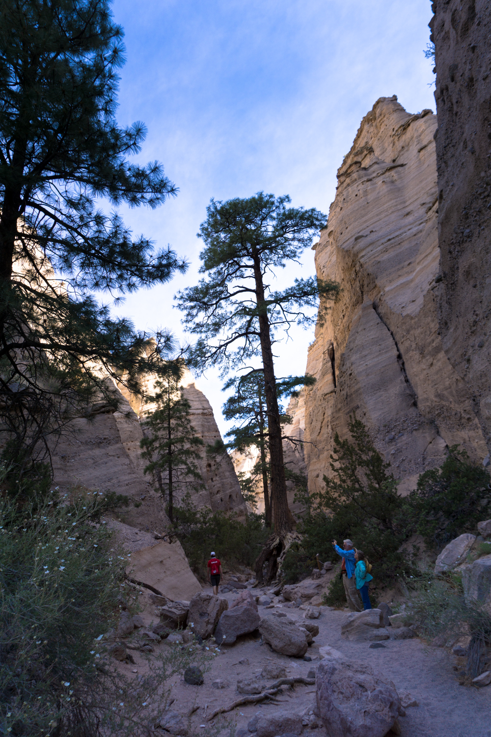
Stunning hoodoo formations tower over you on Tent Rocks Mesa while you meander through some lovely piñon-juniper woodland. The namesake trees do dominate quite a bit here, but you’ll also spot some shrub live oaks and ponderosa pines along with cactus and (depending on when you visit) even some wildflowers on the desert floor, too.
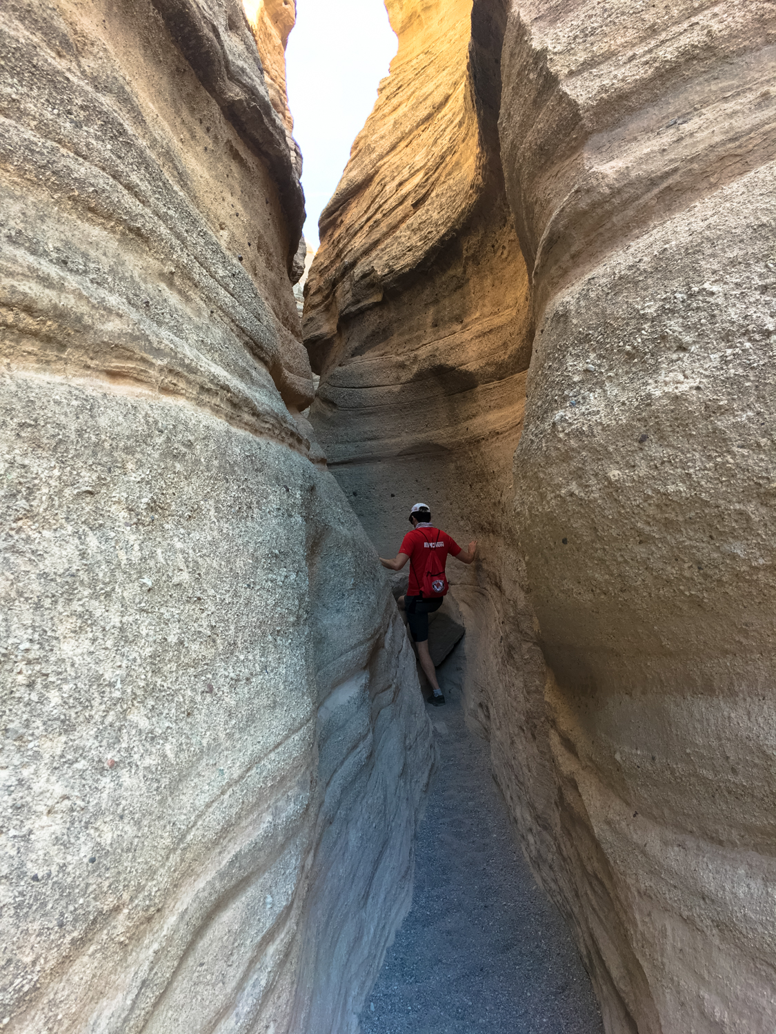
It’s fairly smooth sailing with just a slight incline for the first 0.4 mile. Keep right at the junction here to head to the Slot Canyon Trail, and in another 0.1 mile you’ll find yourself standing at the mouth of the extremely fun slot canyon section near some large ponderosas.

The established trail mostly gives way to a sandy, gravely wash for most of the time it spends inside the slot canyon. Tightly-tied closed-toed shoes will be your friends here. Thankfully, even though there are a few tight squeezes and some sections where you’ll need to use your hands and feet or duck under large boulders, the incline gain remains very gradual here.

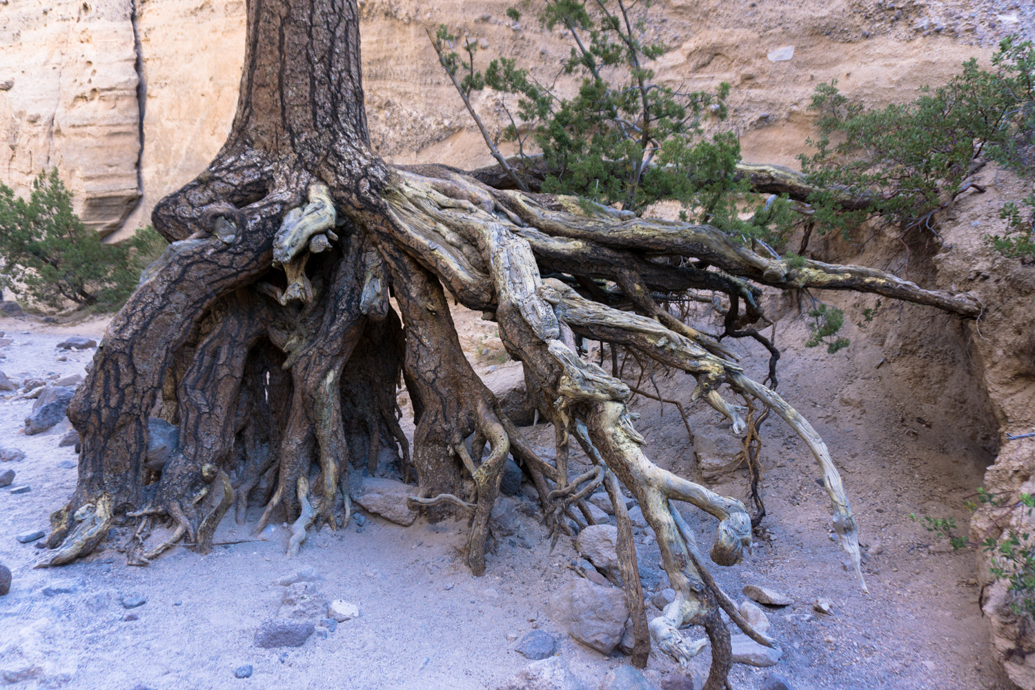
Take the time to enjoy the unique geology — as well as the tough plants who have made their home here in this canyon. Especially impressive are the pine trees whose roots have been exposed from years of flash flooding.


Another reason to try to hit this trail as early as possible is the increased shade from canyon wall shadows you’ll have in the morning. It might make some photos a little tougher to balance, but it will definitely make your hike more comfortable.


Just before the one mile mark, the trail opens up into a broader amphitheater. Shortly after that it makes a sharp bend to the west as it approaches the Tent Rock Mesa.

At 1.1 miles, the trail starts to climb up the Mesa itself — and it gets noticeably more difficult. If you’ve found yourself having trouble on the gradual climb up to here, it might be wise to call this the end point. You’ll have already gone through the slot canyons and gotten up close and personal with the most interesting rock formations … but if you’re feeling up for the incline and want to get a birds-eye view of the tent rocks, march onward!
The trail here meanders through some tight and narrow switchbacks up a steep canyon wall. It’s mostly just moderately difficult hiking, although there are a few sections where you’ll need to use your hands and feet. When you get to the top, though, it’ll be well worth the effort.


The route as described here ends at around 1.4 miles, although there is a short spur trail you can take further down a ridge for some extra views.
When you’re done, head back down through the slot canyons the way you came in, keeping right at the junction with the Cave Loop Trail to avoid the direct line back to the trailhead.

The Cave Rock here is not a naturally occurring cave — it was man-made with rocks and sticks sometime between 1200 and 1540 CE, and you can still make out soot on the walls and ceiling from fires inside the cave (technically, a ‘cavate’). Do not climb up to the cavate or enter it.

This method of carving out rooms into the soft volcanic rock can also be seen at Bandelier National Monument just to the north, where cavate dwellings were located near larger pueblo settlements and kivas of the Ancestral Puebloans.
Follow the Cave Loop Trail back toward the trailhead and you’ll get to pass through a fun section of mini tent rocks just before you reach your car.

Tags: hoodoo, kasha-katuwe tent rocks national monument, new mexico, slot canyon, tent rocks